
I was down in Lone Pine by 8am, seeking out the hostel that provided public showers. Once scrubbed, I asked if there was a barber shop in town, and informed of the one and only hair salon, I walked over to it and asked if they would do something simple like a number one. "No problem, just take a seat", piped up one of the lady hairdressers.
Sue soon had me trimmed and looking dandy. I discovered that she had moved to the area with her ex-husband and now resided in Big Pine. Her parents had moved to North Carolina when they retired, and she simply adored visiting them and that part of the country. The problem was she had to fly out of Las Vegas, not her most favourite of places. She was certainly a lot chattier than Big Norm in Moab, and better looking too. Cleaned and shorn, I was a new man. After purchasing more ice (a 7lb bag would keep bottles of water cool for a day), I headed north up the 395.
|
|
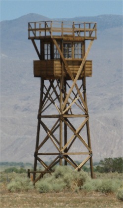 Guard Tower |
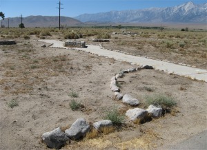
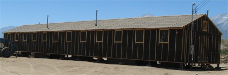 Reconstructed 20'x100' Barracks, 4 Rooms with Eight People per Room |
About two-thirds of all Japanese Americans interned at Manzanar were American citizens by birth. The remainder were aliens, many of whom had lived in the US for decades, but who, by law, were denied citizenship.
The first Japanese Americans to arrive at Manzanar, in March 1942, were men and women who volunteered to help build the camp. On 1st June the War Relocation Authority took over operation of Manzanar from the US Army.
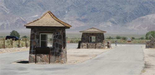 Entry Gatehouses |
In January 1944 the draft was reinstated for Japanese Americans. Most of those who were drafted or volunteered joined the 442nd Regimental Combat Team, which fought with distinction in North Africa, France and Italy. There was a harrowing story of Pfc. Sadao S. Munemori, who a month before the war in Europe ended, was killed when he threw himself on a grenade in Italy to spare fellow soldiers. He was the only Japanese American to be awarded the Medal of Honour during World War II. His mother received the medal while she was still interned at Manzanar.
At the end of the war, the removal of all Japanese Americans from the West Coast states was based on widespread distrust of their loyalty after Pearl Harbour. Yet, no Japanese Americans were charged with espionage. Americans had a hard time after the war, but the Japanese Americans had it far worse.
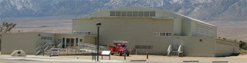 Auditorium Now a Museum |
The 500 acre housing compound was so large that I had to drive round the marked out route, which pointed out where barracks, warehouses, gardens, camouflage net factory, hospital, sports fields etc were. Not many buildings remained, indeed most had been sold off as war surplus after the war had ended. The large auditorium, built by the Japanese, for large functions, meetings and dances, still survived as the museum and cinema complex. Some mock barracks had been erected, one guard tower remained, and the entry gatehouses still stood. Just out side the fence facing the Sierra Nevada laid the cemetery.
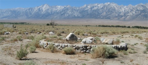
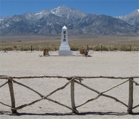 Cemetery in the Shadow Of Mount Williamson |
I had a chat with one of the park rangers at the desk, and asked him if Manzanar was a Japanese word. It was actually Spanish in origin ("apple orchard"), the name arising from the many apple orchards that once covered the surrounding valley. We discussed the site, and eventually the topic shifted on to politics. He seemed to be pro-Obama. He brought up the subject that he was one of those who had fallen through the cracks, he would have to keep on working since his pension became worthless after the latest world financial crisis, and he would still need to keep paying several thousand dollars per year into health insurance. He mentioned how young college graduates were coming out of college with debts amounting to $150k. Crumbs, the UK is not that bad yet.
We harped back to socialism, and he told me that way back before the war, Roosevelt had warned of tyranny and despots taking over the world, and the only way to stop this would be to ensure proper remuneration for work, adequate homes, a health system, a good education system, and a decent pension system were all in place. Indeed he drafted the Second Bill of Rights to move the US in that direction. However, it was overtaken by events during the war, and seems forever put on ice, though Obama may be trying to defrost some of it. The irony was that the Bill became the model adopted by Germany and Japan to aid their recovery after the war.
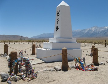 Memorial - "Soul Consoling Tower" |
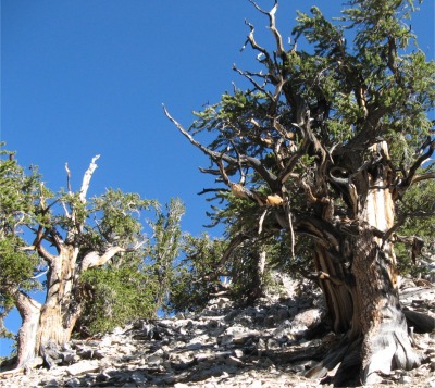 Thriving Bristlecones |
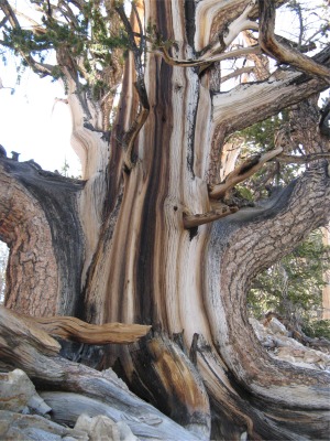 Fantastic Shape |
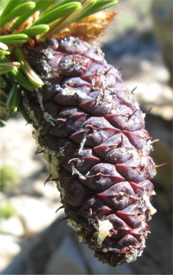
Only 26 miles east of Big Pine lay the "Land of the Ancients", the oldest living things in the world, the Bristlecone Pines. The Ancient Bristlecone Pine Forest was a magnificent ghost forest sitting on the top of the world. The twisted and gnarled trees grew at elevations around 10,000 feet and above, and had somehow managed to thrive in spite of the rough terrain they lived in. The drive from Big Pine started on highway 168, winding up a steep wash through Westgard Pass with its 500 million year old rock formations making them some of the oldest in the region. After approximately 20 miles I came upon the White Mountain Road turn off where I started ascending through beautiful and elegant Pinyon Pine and Utah Juniper groves, and where the switchbacks offered some of the most spectacular views of the Eastern Sierra and Owens Valley.
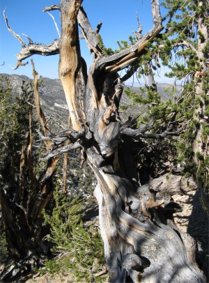 Another Fantastic Shape |
|
|
|

Bristlecones had the ability to let entire sections of a tree die off in order to maintain the nutrient flow to one portion, allowing the tree to continue living. They tolerated alkaline, dolomite soils which gave them the competitive edge over other species. The highest concentrations of Bristlecone trees tended to be found on outcrops of white dolomite. A short growing season produced a highly dense and resinous wood. The trees were as hard as nails, and for that matter so were the dead trees.
While other conifers replaced needles every few years, Bristlecone trees could retain their needles for up to 40 years! This unique needle retention capacity reduced energy demands on the trees, an important adaptation in an environment with only a 6-8 week growing season.
Two species of Bristlecone Pine grew in the Western US: the Great Basin Bristlecone and the Rocky Mountain Bristlecone. Both grew in high-elevation environments, but only the Great Basin Bristlecone attained ages approaching 5,000 years. A third closely related species, the Foxtail Pine, was found at high elevations in other Californian mountain ranges.
I hiked the long trail, and was mesmerised by the beauty in the contorted shapes of these Ancient Wonders. When stripped of bark and clearly dead, the spiral pattern of the grain reminded me of unicorn horns. I passed hundreds of candidates for Methuselah, they all looked ancient to me. The exact location of Methuselah was kept secret to help preserve it. As well as these majestic trees, I came across many wild flowers growing at this altitude; over 10,000'. Of course, this altitude also meant a cooler temperature, which suited me. I passed a chap who was content to photograph virtually every tree in sight. Many dead trees littered the forest floor. I wondered how many centuries those trees had laid there.
Towards the end of my hike, I came across Mike who was sitting on a bench, a chap with long white hair and weather beaten features, and hailed from San Bernando in the south. He too had done the long trail, and said he first walked it over 20 years ago. Now he was in his 60s, he was finding he wasn't as fast as he used to be. It comes to us all in time. He did a lot of hiking, but at this time of year he refused to hike or camp below 8,000'. He did hike the deserts, but only in winter. He was camping down at Grandview campsite, which I passed on the way up, and the ranger had put me onto it. It was a primitive site with no water, and free. It was also at around 9,000', which made my mind up for me. I said I intended to camp there too, and I'd see him down there.
When I got to the site, it was huge and more or less an enormous dispersed campsite, with many secluded areas where vehicles could be driven into out of sight of others. I never saw Mike in all this space. I found a pitch, cooked a chicken chowder with noodles and chunky vegetables, and went off to the pit toilet. Yuck, I would take my chances behind the bushes in the dark.
Once again I had another moonlit night, with juniper trees and sagebrush for company. It was cool, clear air at this altitude. I could see why Mike stayed above 8,000' during the summer months.