What I had enjoyed most of all was the uninterrupted sleep. I almost always sleep on my side, and sleeping in the van always induced cramp like symptoms around my hips. I put this down to the hard wooden board with just a layer of foam for comfort. This had resulted in me turning from side to side every ten minutes or so to alleviate the symptoms, all night long, something which I had got used to during the trip. I experienced none of this sleeping in the bed.
Eggs, bacon and toast for breakfast cost me $2.90; they virtually give stuff away and just rely on the gambling gains to cover their losses. Sadly for them they didn't get a cent out of me for gambling. I checked out and headed to a Walmart I had discovered down the road, in order to buy more ice. As I left the store I asked one of the lady assistants at the exit which was my quickest way to Highway 160, the route I wanted to take to Death Valley. She hadn't a clue, in fact I wondered if she knew where Death Valley was. However, she grabbed a character leaving the store and asked him to explain to me. This guy had well structured facial bones, which were enhanced by expertly applied make-up, and his eyebrows had been carefully plucked, and his hair was gracefully swept back with not a strand out of place. He spoke like a bloke, had a man's arms, and I couldn't tell whether he shaved his legs or not because he was wearing tracksuit bottoms. However he seemed quite helpful, but he couldn't make his mind up out of three or four options, which would be the best. I got the general theme, head west and south in whatever order I wanted, and he gave me a string of highway numbers to look out for. I thanked him, and headed south to the first road junction, and then just drove west until I actually got onto the map of Las Vegas that I had, then I could work it all out.
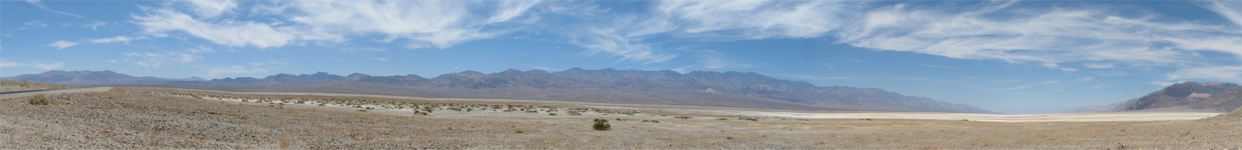
I made sure as soon as I got on the 160 that the van was brimming with liquids, and it was topped up with fuel; Death Valley took no prisoners. I crossed from Nevada to California at the Pahrump Valley, and later traversed Salsberry Pass and then Jubilee Pass in the Black Mountains, at the lower end of the Amargosa Range, before dropping down into Death Valley. This looked very inhospitable terrain. I stopped off at Ashford Mill where the ruins of an old gold ore processing plant could be found. The heat was a shock to the system. It was also combined with a strong wind, and I started thinking if there was an opposite to wind chill for high temperatures. How on earth could people work out here?
Death Valley was named "the hottest place on earth" by a party of white settlers who stumbled through in 1849, looking for a short cut to the gold rush towns. Named features on maps of Death Valley National Park included the Funeral Mountains, Coffin Peak, Hell's Gate, Starvation Canyon and Dead Man Pass - this was clearly a place with a bad history, reflecting the troubles and misfortunes endured by the pioneers who first traversed, inhabited and mined the region during the end of the 19th century.
The area may have had a foreboding reputation, but visitors to the valley today would find a place of amazing beauty with many colorful rocks and canyons, miles of pristine sand dunes, unique evaporative salt features and even a diverse range of wildlife. There were also many relics from a hundred and fifty years of history, which gave an insight into the harsh life of the early settlers - borax and metal ore mines, ghost towns, charcoal kilns and other ruins. Petroglyphs and ancient foot-trails provided evidence of the Shoshone Indians who lived here even earlier.
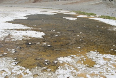 A Pool of Bad Water at Badwater |
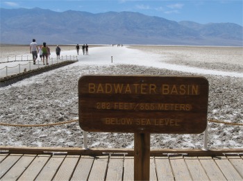 Badwater Sign |
Some miles further up the valley, I came to Mormon Point, which gave an impressive vista across and up the valley. The flats in the valley were white in areas due to salts drying out after rains and floods.
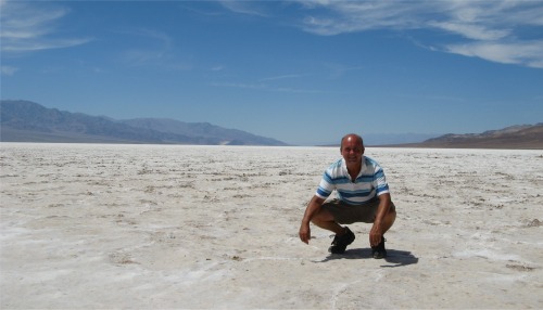 Yours Truly at Badwater - A Cool 124 deg. F! |
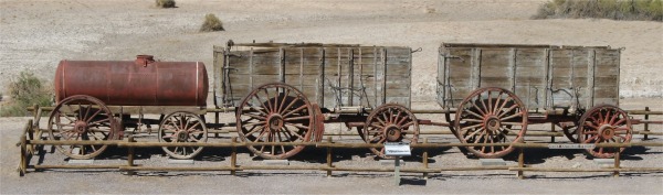 Borax Wagon Pair plus Water Wagon for the 20 Mules |
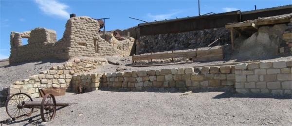 Harmony Borax Works Ruins |
The Harmony plant went out of operation in 1888, after only five years of production, when Coleman's financial empire collapsed. Acquired by Francis Marion Smith, the works never resumed the boiling of cottonball borate ore, and in time became part of the borax reserves of the Pacific Coast Borax Company and its successors. At present the Borax Works plant consisted of a four-level ruin situated against a hillside. There were remains of buildings, machinery, tanks, piping, and waste tailings. In addition to the plant proper, a nearby townsite contained remnants of buildings and trash dumps relating to the company settlement. The entire complex was referred to as "Harmony Borax Works," or simply as "Harmony."
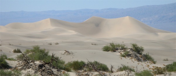 Mesquite Flat Sand Dunes |
I ignored Mosaic Canyon after the village and made the slow long climb over the Panamint Range of mountains. This was quite spectacular, affording excellent views of a once volcanic landscape. I was also pleased that I was gaining altitude, which meant cooler temperatures. Indeed Towne Pass at the top of the climb was 4956'. Shortly after the pass, I rounded a long sweeping curve and was confronted with Panamint Valley far below me. I could see the road crossing the flats in a straight line and climbing up to Panamint Springs on the other side, and I was still miles away from it. The drop down to the valley was exhilarating. At times going down hill I could see the road disappearing as it curved down, and as I approached the brow of the hill, I expected to see the road again, but it wasn't there, the road was still curving away at an even steeper gradient. This was a little unnerving, not unlike being on a roller coaster just before it makes its vertical drop. Eventually I did get sight of the road, but what the gradient was I'll never know, just b****y steep.
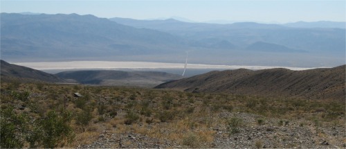 Panamint Valley and Road Far, Far Below |
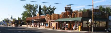 Lone Pine |
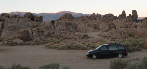 Dispersed Site in Cowboy Movie Country |
It was a gorgeous peaceful setting with wonderful shaped rocks in all directions. Then the peace was shattered by a jet aircraft flying low overhead. I soon figured I was near an Air Force Base and the pilots liked to practice their tight turns in the area. It was interesting to watch them turn on a sixpence; there must have been a lot of G-force being pulled there. Fortunately they packed up for the night after 10pm. It was still warm up here, but not the raging inferno I had been experiencing at lower altitudes. My notes were typed up by midnight, and I had to answer a call of nature. It was almost a full moon, and walking around these rocky outcrops in moonlight was a lovely experience. I thought about snakes and scorpions, but the sheer beauty of my surroundings soon overcame those thoughts. I looked forward to some decent sleep again.