


After my sumptuous porridge, I posted five CDs of photos back to the UK, and power washed the van to soothing music being blasted into the spray booth; I rediscovered the van colour was navy blue. Then, without delay I headed of to the Island in the Sky section of Canyonlands National Park.
Millions of years ago the Colorado and Green Rivers cut winding paths deep into the rock, creating a labyrinth of rocky canyons that form the heart of this stunning wilderness. At its centre, the rivers' confluence divides the park's 527 square miles into three districts: the Needles, the Maze, and the grassy plateau of the Island in the Sky; all vast and very different regions. The areas share a common primitive spirit and wild West atmosphere, each offering its own rewards. Few people were familiar with these remote lands and rivers when the park was established in 1964. Only Indians, cowboys (Butch Cassidy hid out in the Maze canyons in the late 1800s), river explorers (e.g. John Wesley Powell), and uranium prospectors had dared enter this rugged corner of south-eastern Utah.
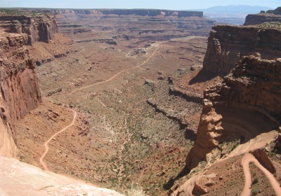
Views from the Island in the Sky reach from the depths of the Green and Colorado Rivers to the mountaintops and above. They stretch across canyon after canyon to the horizon 100 miles distant. Island in the Sky - a broad mesa wedged between the two rivers - serves as Canyonlands' observation tower. From here could be seen vistas of almost incomprehensible dimensions. 1200' below the Island was the White Rim, a nearly continuous sandstone bench of the hard white rock variety. A trail for 4x4s existed along its 100 mile length, and estimates of at least two days were required to complete it. Another 1000' feet below the White Rim were the rivers, shadowed by sheer canyon cliffs.
 Shafer Trail |
Traveling further south I came across more stunning viewpoints: Buck Canyon, Orange Cliffs and Grand View Point Overlooks. All looked out over vast tracts of land that at one time must have been level as far as the eye could see. But now, due to the forces of erosion, a 1000' lower plane had been created, in which numerous valleys were carved and two rivers wound there way 1000' lower still. The panorama shots can't do the vistas justice.
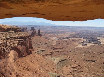 Looking Through Mesa Arch |
By the time Powell's party reached the confluence of the two rivers in July, one boat had been smashed, and provisions were low. But he found a unique landscape that drew national attention. Powell's journal stated, "We glide along through a strange, weird, grand region. The landscape everywhere, away from the river, is of rock," with "cathedral like buttes towering hundreds or thousands of feet, cliffs that cannot be scaled, and canyon walls that shrink the river into insignificance".
It was a voyage of scientific discovery, but also one of the world's great adventures. Today's adventurers run the river in rubber boats, but they see a wild landscape that has changed little since Powell's time.
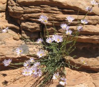
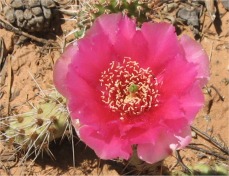
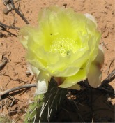
I headed back north to the Green River Overlook where the river could actually be spotted meandering between the sheer canyon walls. A sort distance further brought me to the Aztec Butte. I walked a trail which crossed sand dunes to the base of the butte. I came across beautiful flowers crossing the dunes, including the prickly pear cactus. Earlier in the day I had asked an elderly lady about a plant that had also intrigued me but nobody seemed to know what it was. She explained to me it was a Yucca. Like many desert plants, it had a succulent stem, tall in the Yucca's case, and spiny leaves at the base. The plant was a favourite of the Indians. The stem contained long fibres that could be used for tying, and the prickly spines served as needles when dried. The sand dunes made me wonder, here I was walking on sand that had probably been produced by erosion of sandstone over millions of years, the sandstone having been produced form sand at an even earlier epoch in time. The temporal and physical scales of the region were beyond my comprehension.
|
|
|
|
|
|
|
This had been a lovely introduction to Canyonlands; the wilderness, remoteness, ruggedness and mystery, it all appealed to me.
In the evening I strolled down to Eddie McStiff's for some food. It seemed like a lively place. In the corner a bass player, banjo player, and a female guitar player/singer played out songs that I couldn't say were country and western, in fact I couldn't say what they were, but it got feet tapping and a few folk up dancing. As in all bars there was a minimum of two TVs showing sports channels. I noted England was playing Slovenia in the morning, but I wasn't keen on the idea of a 7:30 am kick off US time though. The food was good, the atmosphere was good, and I left content but whacked.