With clear skies overhead, I had indeed been treated to another freezing cold night. I packed up and made haste to continue my journey south. The van charging system was still playing up; I just wanted to understand what the problem was. I had by now identified it was the combined alternator/regulator unit, but I did not know what could be creating the intermittent fault.
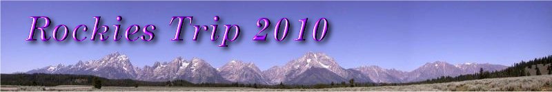
Long Unwinding Road
|
Not may cars were using the road, perhaps because it was Sunday. The road stretched to the horizon straight as an arrow. When you look at a map of Alberta past the Rockies area, all the roads are marked as a grid structure. That's exactly what they are, straight for miles and miles.
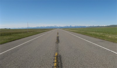
Bar Eleven Ranch
|
With only the occasional deer to break up the monotony, I ploughed on; the landscape changing from undulating pastures to almost flat priarie. The snow capped Rockies were always lurking in the distance. Only the occasional ranch reminded me that people lived here. Side tracks lead off into the distance, and I'm sure there must have been real cowboys or organised cowboy type activities for the thrill seeking tourists at the end of these tracks. I saw none of this, just cattle and sheep grazing the endless grassy terrain. I took a break for a short walk in this land to try and get a sense of the Cowboy Trail. My experience was akin to standing by Ermine Street in Britain trying to get a feel for the Romans.
After a couple of hours driving, I came across a sign pointing to Leitch Colliery. I have a fascination for mines, my ancestors made their livelihoods in them. I decided to have an impromptu explore, and made the detour along the Crowsnest Pass Road. This road was a major route across the Macdonald Range into British Columbia, and the pass became more significant when the railways crossed it in order to transport rich mineral deposits found in south west British Columbia. When the track was being laid, prospectors discovered rich seams of coal along the valley, leading to many mines being opened up. Leitch was one of these mines, and like all the mines in the area, prospered while the locomotives were steam based. However, the slump after the First World War saw a decline in business and the mines all closed. As I was about to leave the old mine, the curator turned up, who explained to me that most of the materials that the mine surface buildings were built from was plundered after the mine closed. She informed me about the Bellevue Mine a few miles up the road where you could actually get a guided tour. I thanked her and headed up the road.
There was little surface structure left at Bellevue Mine, plundered I presumed. However, I did get a guided tour. The mine was a tunnel mine, known as a drift mine in Britain. I knew the workings and processes of mining, so I was on a level footing with the young girl who guided me, and I could also share my knowledge with her. She seemed to appreciate that. What I found fascinating in this mine was how the wooden props were arranged at angles because the coal seams were set at inclines of 30 - 60 degrees. She also pointed out a 'Welsh Notch' to me, something I had not come across before. Basically, when two props met, there was always a small gap or notch set in between them where a small piece of wood would slide. If the mine roof was starting to shift, the small piece of wood would either fall out or be locked tight into place. There was hardly any toxic gas at this mine, but it really stunk of hydrogen sulphide (rotten eggs). The girl pointed out a spot where water was trickling down the wall of the tunnel, leaving a white deposit where it ran. This was sulphur laden water. She recounted how at one time, people used to drink such water for its health giving properties. It reminded me of the Pump Room at Harrogate; how could people drink that vile liquid? An entrepreneur opened up a spa and accommodation to make his fortune. However, it turned sour when it was later learnt that sulphur was also a good laxative. She also mentioned about the breathing apparatus that some mines in the area issued to their miners in case toxic gasses pockets were broached. These masks contained some fiendish chemicals that had a side effect of blistering the whole face off. Some miners refused to accept them. Those were tough days. At the end of the tour I had a chat with the girl and curator about mining in Cumbria. I had found that due to superstition, woman were not allowed to work at Canadian mines, but I pointed out that my grandmother used to work at the surface workings as a young woman. I was not at all clear which was the right approach. I said my farewells, and departed, thankful for this unexpected diversion.
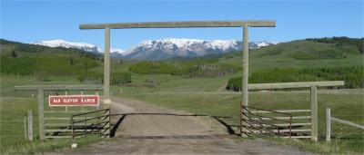
Deer in Waterton Village
|
I continued on my journey across a featureless landscape and considered another detour into the Waterton National Park. With my crack of dawn start, I had time to spare. The park was named by Lieutenant Blakiston to honour Squire Charles Waterton, a British Naturalist. Blakiston (for whom the park's tallest mountain is named) was a member of the Palliser Expedition, sent by the Queen of England in 1857 to explore the economic potential of the lands that later became western Canada. The park lies in a beautiful valley on the eastern flanks of the Rockies, and to me it looked not unlike Ulswater in the Lake District. Waterton Village lay at the junction between Middle and Upper Waterton Lakes, and reminded me much of lakeside villages you would find in the Lake District.
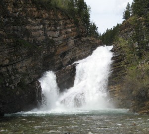
Cameron Falls at Waterton Village
|
I stopped to chat to a couple of Mounties doing their PR stint and becoming minor celebrities for the day. Their uniforms and boots were pristine. They even had gleaming 25 year service medals too; good ambassadors they were. I asked a local builder about the Prince of Wales Hotel, which stood apart from the village on a small hill. This elegant hotel which is now recognised as a National Historic Site, was built in 1927 by the Great Northern Railway, in 10 months apparently. Whilst it was being built, when only the framework was up, strong winds, that typify the area, moved the top gable beam by five feet. The builders pulled it back into shape with huge cables, which are still incorporated in the building. The builder told me the reason for the hotel being built was due to American Prohibition. A hotel chain in the U.S. just over the border wanted to be able to offer customers alcoholic beverages, hence the reason for the Prince of Wales Hotel which was within easy reach.
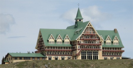
Prince of Wales Hotel
|
|
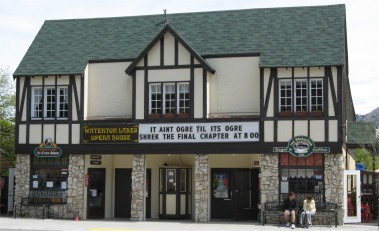
Waterton Little Opera House
|
|
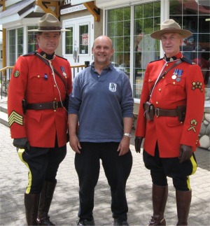
Close Arrest by the Mounties
|
I sat by the crystal clear waters of the Upper Waterton Lake, the deepest lake in the Canadian Rockies, sipping root beer and pleased with my unexpected detours. The sun was shining, a cool breeze; just bliss.
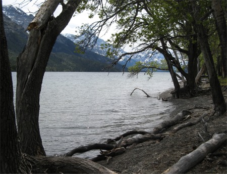
Upper Waterton Lake
|
I toyed with the idea of a boat trip on the lake, but it would be over two hours long, so I departed this delightful setting and made tracks to the Canada/U.S. border crossing at Carway. I was there in less than an hour. The official at the U.S. entry point was very officious: who owns the van, why was it registered in Washington, how much money have I got, where I was staying, was I importing alcohol, fruit, weapons etc. I showed him my apple and told him about the five bottles of beer which have been in the back of the van for two weeks. He got out of his office, demanded I open the back, and told me to stay in the van. He then searched my stuff for what seemed like an age. On returning to his office, "Where are you heading now?", to which replied that I was heading to St Mary, camp the night, and would take the "Going-to-the-Sun Road" across to Flathead Lake in the morning. He informed me that the 62 mile long road across the Continental Divide was closed, the snow had not been shifted yet. I could drive along for 13 miles, but would have to turn back. I was really annoyed at this. When I was first planning this trip, the road was high on my agenda. The literature I had read said it normally opened about the third week in May. Photographs I had seen showed cars passing through snow alleys in May, the snow being twenty feet deep on each side. The chap said it might be late June early July before it opened. Crumbs, must be really bad conditions up there. It was a pity since it was meant to be a stunning drive. So I discussed an alternative with the official, and he gave me a map too; kind man.
I made the final drive down into St Mary, a place as exciting as the end of Felixstowe Pier. I asked some motor cyclists where the best campsites were, half of the older guys were almost deaf; I don't know if they played in bands or worked in noisy environments at one time. I then headed up by St Mary Lake for six miles to another self registering site. The road there was actually the start of the "Going-to-the-Sun Road", and I could see in the distance along the road, mountains like sheer white slabs of snow. It did look grim up there.