
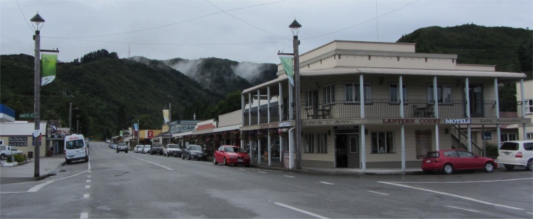
 Downtown Reefton |
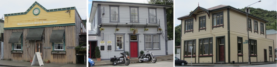 Old Buildings in Reefton |
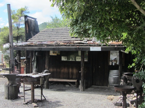 Bearded Mining Company Hut |
Hawks Crag was a prominent landmark in the Lower Buller Gorge, where the road had been cut into a cliff that dropped into the Buller River. Constructed in 1869, it stood as a tribute to the spirit and determination of the West Coaster, who overcame many difficulties in its construction. The gorge had been a challenge to horsemen, coach drivers, roadmakers and bridge builders. Today, the road was reckoned to be one of the best scenic drives in New Zealand.
I took a turn off and headed south for Reefton, also known as "The Town of Light". With a population of 1200, the town has occupied its riverside site since 1872, in spite of several attempts by the Inangahua River to remove it. It owes its origins to the discovery of rich quartz gold reefs. The town quickly sprang up with timber hewn from the surrounding birch forests, and has never lost its special pioneer timber-and-iron character. The underground quartz mining lasted through to the early 1950s when the last mine closed at Waiuta. The old Globe Progress mine has been re-opened and gold mining has returned using opencast methods.
Reefton is a living, working heritage town with extensive historical sites and buildings. With a population of 1000, the town maintains a vibrant community spirit wrapped around the town's historic past.
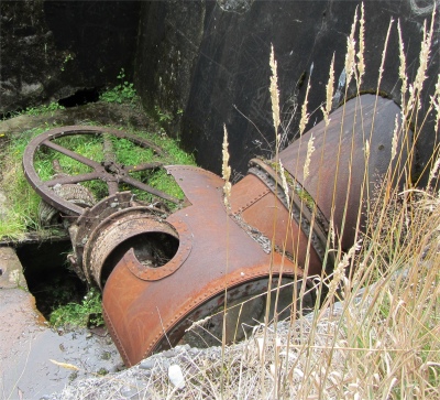 Old Powerhouse Remnants |
"Did you fellows work in any of the local mines?" I asked, trying to kick start some dialogue. There was a long pause, perhaps some quirky time-space continuum slowed down the speed of sound across to their ear-drums. "No, none of us did," answered one guy. "My father was dead against me working in the mines," he added.
"What mines are still being worked around here?" I persevered. There was a good 40 seconds of silence, followed up by, "The old steam engine in the i-Site centre came from England." Not quite the answer I was expecting. Our conversation proceeded in a similar disjointed manner, and I had to bite my tongue at times waiting for the next tangential comment from the chap.
One of a never ending procession of large trucks with trailers passed by, laden with coal. "That's from the open cast coal mine," he said. Progress at last! Similar to the hills around Denniston, the old coal fields are being scalped and coal was being scraped off ancient seabeds. The increase in the price of coal had now rendered this a viable proposition.
 1968 Inangahua Earthquake Slip |
There was not much left of the old powerhouse now, just the rusting remnants of an old turbine and generator inside the shell of a concrete building. A walk past the building by the river was very pleasant, now the sun was out, and the crystal clear waters of the river showed a golden yellow river bed, more due to the run-off from the hills rather than stones of gold.
A further two kilometres past Reefton lay the Blacks Point Museum. Inside I was warmly greeted by Peter Lawn, an ever so friendly and chatty chap, who proceeded to give me a personalised guided tour around the museum. I was his first visitor in a few days according to the signing in book.
He showed me working models of a quartz stamping mill, a static model of a mine, and heaps of memorabilia concerned with mining, engineering, printing, butter-making, shoe making - virtually everything you would find in an industrial community. With all the exhibits, which often had photographs of locals associated with the exhibits, he was able to recount tales of these people, and bring it all alive.
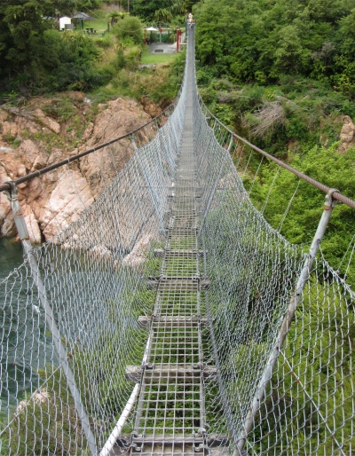 Buller Gorge Swingbridge |
The museum was located in a former Methodist church. The Cornish men refused to work on Sundays, and seemed to have got away with it. I had learned in Denniston that mine owners there were often at loggerheads with religious leaders, who were regarded as trouble makers. Indeed, one ship load of miners and their families had been turned away from the Denniston Plateau because it was feared they had been tainted with the religious views of several priests on the ship. That was indeed a severe hardship after travelling halfway around the world.
I shared with Peter my story about the west Cumbria jam-eating miners, which he listened to with great interest. He said that there had always been jam on the table in his family, and perhaps that what they used down these gold mines. It got him thinking. Perhaps the Cornish men did migrate from pasties to jam butties in their newly adopted country.
I thoroughly enjoyed my tour around the Blacks Point Museum, and gave a hearty farewell to Peter. Long may the museum continue.
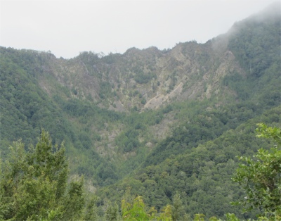
I retraced my steps back to the main road where I had turned off, and carried on towards the east. On the way I passed the huge slip which began as a result of the 1968 Inangahua Earthquake, completely damming the river and creating a temporary lake. Today the slip is partly covered in native forest.
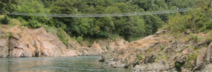 Profile of Buller Gorge Swingbridge |
As the population swelled in 1869 the goldfield warden called for a police station. Some "notoriously bad and ruffianly characters" had found their way to Lyell. "some serious breaches of the peace have occurred and on more than one occasion it has become necessary to despatch constables specially to that locality to apprehend offenders of this sort".
 A Walk Down White Creek Faultline |
Even the most glamorous event could be the occasion for a good fight. An 1872 report on a successful ball to which "the fair sex mustered strongly and in elegant costume. The ball finished up in the usual style with two or three fights shortly after daylight, quite a common occurrence at Lyell, but we are nonetheless friendly afterwards".
Lyell's most famous gold digger was also its smallest, Bridget Goodwin, better known as Little Biddy of the Buller. Born in Ireland and a staunch Protestant, Miss Goodwin was a veteran of the Australian and Nelson goldfields when she arrived in the upper Buller during the 1860s with her two male mates. Eventually they shared a hut near the Iron Bridge and a gold claim where Biddy directed operations and did more than her share of the toiling.
Her four foot girl-like figure was familiar at Lyell, buying supplies and spending the rest of her earnings on tobacco (the stronger the better) and whiskey (knocked back neat). After outliving both men Old Biddy (as she was by then) retired to Reefton, dying there in 1899, aged 86.
Today, nothing remained of the once thriving town, apart from swarms of sandflies. I carried on to Buller Gorge Swingbridge. Here, an adventure heritage park could be accessed by the country's longest pedestrian swingbridge, 110m long and 17m above the rushing waters of the Buller River.
I proceeded over the bridge at a brisk pace, making sure I kept my hands running along the cables on either side; it had an appreciable swing on it. Running in parallel alongside the swingbridge was a 160m-long zipwire. Folk were hurtling along the wire imitating Tarzan, Superman, and probably postman Pat for all I knew. It looked fun. The last time I had flown down a zipwire was when I took my kids canyoning whilst on an activity holiday in Turkey. We were individually sent to our doom through a waterfall, and it wasn't until we shot out of the other side that we realised we were hurtling high up over a void with black rocks and mists below for 100m or so.
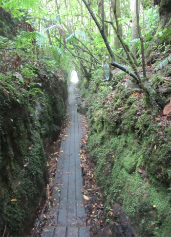
On the far side of the bridge I tackled the 15 minute loop walk around a peninsula on the river, basically because I wanted to walk across the famous White Creek Faultline, epicentre of the 1929 Murchison earthquake, where the ground was instantly thrust up 4.5m. Bush had walked all over the faultline by now, as well as miners, but the displacement was still clear to see. The amount of energy expended in shifting the surface of the earth was beyond my comprehension, but was also a fact of life for New Zealanders.
The final leg of today's journey took me to Murchison, a stop-over place for my journey to the Abel Tasman National Park. The small town was at the head of the Buller Gorge and the confluence of the Buller and Matakitaki Rivers, and the northern gateway to the West Coast. This too had been a gold mining town, and had been almost wiped out by the 1929 earthquake. I passed an hour or so in the evening at a bar in town, in the company of three lorry drivers who were a complete hoot.
One of the drivers lived on the North Island, and was affectionately known as the "pig" by the others. He was a keen fisherman and always looked forward to time off to go out with his mates for the big marlin. Just after the Christchurch earthquake, he and his mates spent a weekend fishing, smoked all the fish they caught, packed them and one of the haulage companies ferried the 800Kg load down to Christchurch for all the workers involved in the clear up. These big blokes were big hearted too.