new_zealand_banner
...... previous day next day ......
Doubtful Sound Queenstown

19th January 2012

An Extremely Wet and Windy Day in a Land Laced with Hundreds of Waterfalls

chasm
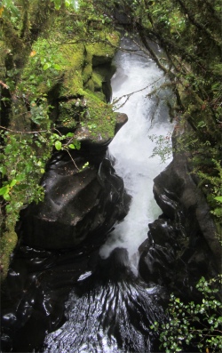
The Chasm from Above
    On my way to the shower block I bumped into the Norwich chap. He and his wife were on their way to Milford Sound, then heading down to Invercargill just so that he could say he had travelled the length of the country. We shook hands and wished each other safe journey, thinking that this would be the last time we would cross paths again.
    In the communal kitchen where I was sorting out my deluxe breakfast of cereal and coffee, I bumped into Tony and his wife, who had been in the next pitch to me at Geraldine. The world is indeed small. He had been to Milford Sound the previous day and was off to Invercargill today, and then the Catlins. Who else would I meet I wondered.
the_mitre
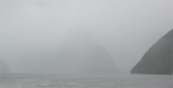
The Mitre Almost Hidden in Rain
    The morning was disturbed by an air-raid siren. These go off at unearthly times of the morning, usually around 8am, and are tests conducted by the local civil defence volunteers. The civil defence quite often get short slots on the local radio stations, when they advise folks what to do if an earthquake occurs. Also, for those near the coast, I learned the yardstick is that if the quake is so bad that you can't stand, then you must immediately head for high ground because of the possibility of a tsunami; once you can stand of course.
lacework_of_falls
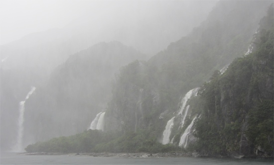
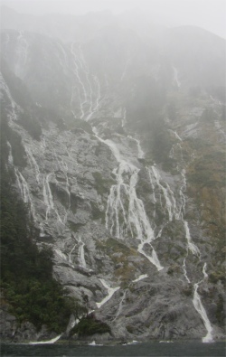
A Lacework of Waterfalls
    Soon I was ready to depart to Milford Sound. Te Anau was the start of the Milford Road, the Highway to Milford Sound, which lay at the end of a 120km cul-de-sac to the north, and effectively the only road that enters into the interior of Fiordland National Park. I set off early to avoid the countless tour buses heading up the same route for midday cruises. The Maori followed this route to seek treasured pounamu or greenstone at Anita Bay on Milford Sound, but no road existed until 200 navvies started the job in 1929 with picks, shovels and wheelbarrows.
fierce_winds_in_milford_sound
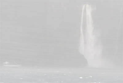
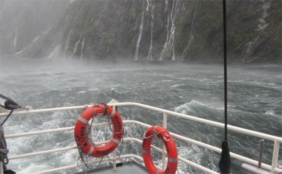
55 Knot Winds at This Narrow Point
    The road was a sheer spectacle in its own right. It deceptively meandered through gentle, rolling, green and pleasant pastures beside Lake Te Anau's lateral moraine. After Te Anau Downs, the road entered the national park and the scenic extravaganza of Eglinton Valley, crossing alluvial flats with occasional stands of silver, red and mountain beech, hemmed in by sheer mountains on either side. I stopped off at Mirror Lakes to look at the oxbow lakes which reflect the peaks opposite in calm conditions. The crystal clear waters were ruffled by a strong wind, so no reflections today, but I did see an electric blue fish prowling the waters below me. He soon cleared off when another two coach loads of Japanese tourists appeared with their flashing cameras.
    Towards the head of the valley, I started to climb up to the Divide. The 532m high Divide was the lowest east-west crossing of the Southern Alps. There wasn't much here apart from a car park with toilets, and a large walker's shelter. This marked the start/finish point of the Routeburn, Greenstone and Caples tracks. Declining the walking opportunities here, I headed on, descending partly into the Hollyford River Valley, before veering west along the main road towards the huge glacial cirque of the Gertrude Valley, the source of the Hollyford.
inverted_falls
Waterfalls Being Blown Back up the Cliff
    The road climbed with precipitous mountains closing in on either side, eventually reaching what appeared to be a high, blank wall, whose base soon revealed the entrance to the Homer Tunnel, complete with traffic lights to enable one-way traffic during the summer months. The colossal granite walls here were awash with waterfalls emerging from the snowfields high above. Rains were torrential, and the wind vicious, indeed it was whipping up some of the waterfalls and sending them shooting straight back up to where they originated high in the swirling mists. The road builders reached this obstacle in 1935, and started to tunnel through the headwall of the Hollyford Valley in 1935. This was a major feat of engineering, working at a one-in-ten downhill gradient, constantly being plagued by water. By 1948, the 1200m Homer Tunnel was completed. Driving through the tunnel, water was still dripping down from the dark, rough-hewn walls.
boat_near_falls
Ship Venturing Near a Set of Falls
    Then, all of a sudden I emerged into the other side of the granite mountain, and immediately started to zigzag down through a series of switchbacks into the rain-forest-carpeted depths of the Cleddau Canyon. Milford Sound was named after Milford Haven in Wales, while the Cleddau River which flowed into the sound is also named for its namesake which flowed into Milford Haven. Some way down the canyon I stopped and took a stroll across to view The Chasm. Here, the Cleddau River plummeted through an almost vertical narrow chasm creating steep falls and fantastic eroded rocks resembling flying buttresses and a natural bridge.
water_everywhere
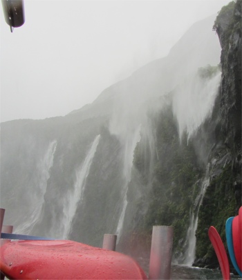
Water Water Everywhere
    Just as I was leaving the Chasm, I met the Norwich couple yet again. They had been to Milford Sound, had a coffee, and were now on their way back. Knowing that our routes would be totally divergent from this point on, we said a final farewell and safe journey.
    A short drive brought me down to the silky-black waters of Milford Sound. It ran 15km inland from the Tasman Sea and was surrounded by sheer rock faces that rose 1200m or more on either side. Across the waters in front of me, occasionally through the banks of rain, appearing as a grey looming glaciated mass, the sheer-sided 1692m slab of rock called Mitre Peak dominated the sound. Other notable worthies were the Elephant at 1517m and Lion Mountain, 1302m, all obscured by the curtain of rain. Lush rain forests clung precariously to these cliffs, with the odd gap where gravity had won the day and torn vast chunks of the vegetation away from the rocky faces and cast it into the watery wastes far below.
    The grand scale of Milford Sound was best appreciated on one of the many boat cruises on offer. I had picked out a suitable cruise whilst in Manapouri, the nature cruise aboard the Milford Wanderer. For some odd reason, the car park at Milford Sound is a 10 minute walk from the cruise departure point. After just 100m of this walk, I was totally soaked from my hips down; just dandy.
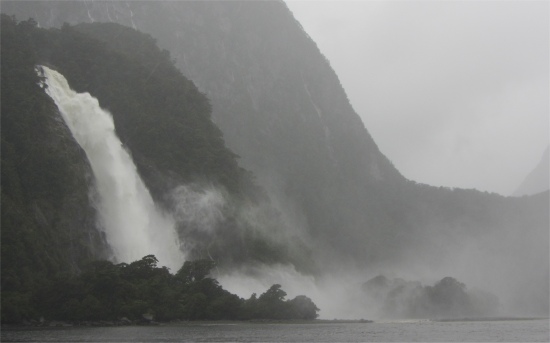
bowen_falls
Bowen Falls
    Once on board, I took in the sturdy vessel which recently had a refit, and was now beautifully furnished with a varieties of timbers throughout. I settled in with my cruise mates, a family from Melbourne cramped around the same small table. I was prepared to be dumbfounded by the unfolding mystical, breath-taking scene; perhaps New Zealand's most renowned iconic landmark. The boat would be traveling out to the open sea, passing under a waterfall torrent to thrill the passengers, as if the "rain experience" in this neck of the woods was not enough. The excellent commentaries explained how a giant glacier gouged out the fiord, the deepest point of the fiord, near Stirling Falls, was 300m below sea level. An 80m deep sill, created by a terminal moraine at the narrow entrance, connected the sound to the external continental slope. This effectively impeded tidal flows and allowed fresh water to form a 10m layer on the surface of the sound, tannin stained due to the run-off from the surrounding cliffs. As a result, black coral could be found at relatively shallow depths inside the sound.
    The fiord sported two permanent waterfalls all year round: Lady Bowen Falls (173m) and Stirling Falls (160m). During todays heavy rain however, a lacework of many hundreds of temporary waterfalls could be seen running down the steep sided rock faces that lined the fiord. They were fed by rain water drenched moss and would last a few days at most once the rain stopped. Heavy rainfall was a regular feature of this region with up to seven metres being experienced in some years. There was an upside however. On the 182 rainy days of every year, the whole landscape would take on a brooding, mystical quality and the sheer granite walls burst out into hundreds of spectacular waterfalls. Whole mountains came alive with waterspouts and cascades, creating a very dramatic photogenic "mood" scene.
kea_on_mirror
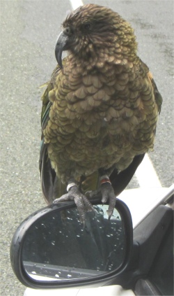
Kea Trying to Break Into My Car
    The fierce wind was whipping some of the falls back up the cliffs down which they were tumbling. At the narrowest point of the fiord, where its width drops to only 400m, the howling winds were funnelled into a gale, shearing off the tops of waves. The captain reported a wind speed at this point of 55 knots!
    Our craft slowly motored over the turbulent waters which were populated by white seals, penguins and dolphin. On a calm day the nature cruise would have been busy spotting all this marine life. Today, just a couple of seals and their pups were spotted on a large rock. The boat hugged the cliffs, occasionally taking a mist filled shower from one of the vertical torrents of water, and I soon found we were crossing the sill of the fiord and our craft was being pounded by the choppy swells coming in from the Tasman Sea, with great spumes of salt water adding to the experience. From here it became obvious why it took 50 years from Cook's first sail past the fiord before anyone actually found there was a fiord at all. Due to a kink in the fiord at the entrance, it appeared to be just a large bay. After a few hilarious soakings, we resumed our trip back up the fiord, and just soaked up the majesty and scale of our surroundings, or what we could see of it. I was mesmerised by the water somersaulting off ledges of glistening, dark bedrock, bursting into spray; the whole mountainside an intricate tumbling aquatic lacework. Awesome was the only superlative that did justice to Milford Sound, whose towering granite walls would simply dwarf cruise liners, and left human impacts on the landscape looking like a world in miniature.
    The original impacts in the area were created by the first settlers at Milford: Donald Sutherland, J. McKay, and J. Malcolm who, in 1877-80 built permanent huts both at the head of the fiord and at Anita Bay near the entrance. At first they were interested in deposits of asbestos and greenstone at Anita Bay, but in later years Sutherland married and settled down in the homestead at the head of the fiord.
    As we passed close to Stirling Falls, the captain announced, "Now ladies, we are going to get close up to these falls. The legend has it that the spray from them landing on a woman's face would make her look 10 years younger." A story of course, but I was amazed how 90% of the women trooped out in the rain for a good soaking in the spray. No comment.
    All too soon we were back to our departure point. The cruise had been a total contrast from my Doubtful Sound experience. Despite being soaked through for the entire trip, I was glad I'd seen this rugged land in its rawest form; it added to the Kiwi experience.
Panoramic View of a Small Section of Lake Te Anau      (please use scroll bar)

    I got back to my wagon, peeled off my wet clothes and attired myself in drier versions, put the heater on full, and drove the long 120km back to Te Anau. The sun was shining brightly over Lake Te Anau, and I found there had only been a light shower here in the morning. The Southern Alps truly are the great dumping grounds for the moisture laden winds coming in from the Tasman Sea.
    As I typed the bulk of this blog this evening, I felt the building move a little. The effect lasted for about 15 seconds; I assumed it was the wind and thought nothing of it. Later, I heard some locals talking about the earth tremor. Now that I have experienced one, I can say in hindsight that I did experience a few in Christchurch too. The locals don't seem the slightest perturbed by it though.


...... previous day next day ......
Doubtful Sound Queenstown

Uploaded from Uploaded from Great Lakes Campsite, Te Anau on 19th January at 21:30

Last updated 19.1.2012