6th January 2012
Hiking on the Great Divide with the Botanists
|
|
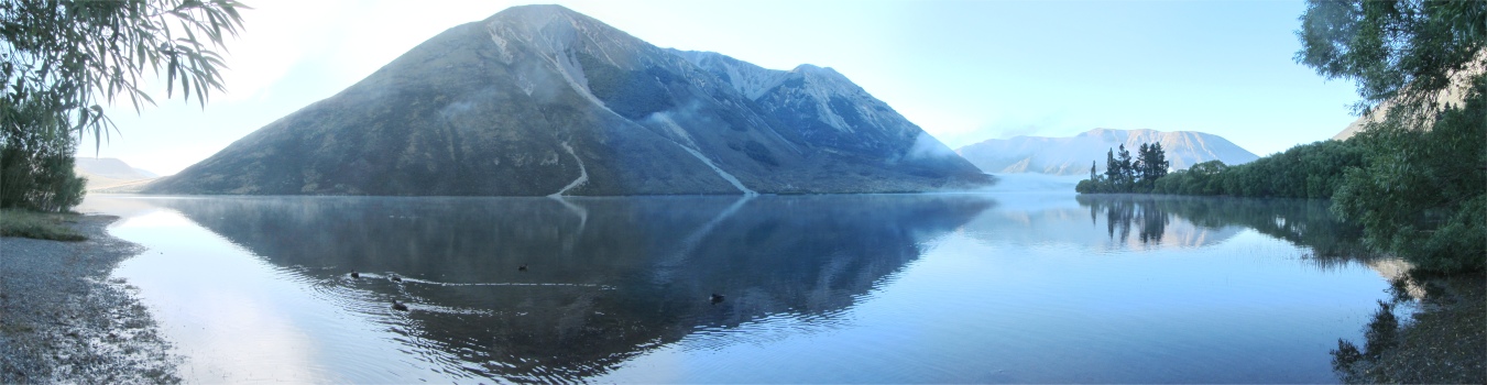
Panorama of Lake Pearson at Dawn From My Pitch (please use scroll bar)
|
Straight to the Heart of the Southern Alps
|
I woke up early to discover a layer of mist hugging the hour-glass shaped lake, and the tips of the surrounding peaks all aglow as they were bathed in the newly risen sun. I took it in for a while, and then tucked into cereal by the lake. This was a rather short affair, I was eaten alive by sand-flies. I quickly coated my exposed bits with repellent, and then started my drive up to Arthur's Pass.
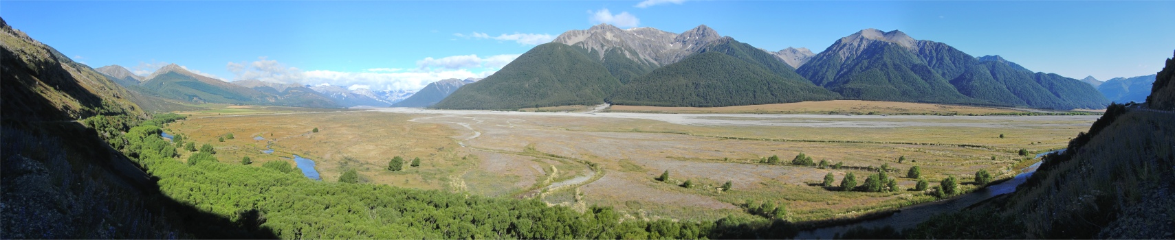
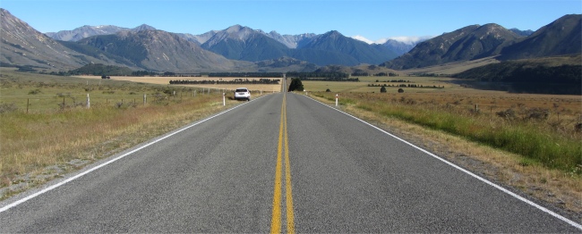
It was a lovely drive, passing herds of sheep and cattle that coped quite well at these altitudes. The highway skirted the braided Waimakarira River, then skimmed flat valleys, and at times clung to huge spurs that jutted out into the valleys. Snow was dappled about the upper slopes, and it was all very scenic picture postcard material. The roads gradually narrowed as I climbed towards the pass.
Located along this route and in the heart of the Southern Alps, lies Arthur's Pass National Park, established in 1929, New Zealand's third national park and the first one in the South Island. I had enjoyed my stints of high altitude walking in the Canadian/American Rockies the previous year, and I wanted to hike around similar terrains down under. Hence I was drawn to this national park like a magnet.
I was treated to glimpses of clear mountain water rushing through wide shingle riverbeds. Dark-green broom sat behind shaggy, cinnamon-brown tussock, while snow-frosted mountains lorded over the whole scene. I proceeded in this idyll up to Arthur's Pass Village, nestled in a glacial valley at an altitude of 900 metres and New Zealand's highest settlement, and of course within the Arthur's Pass National Park. Arthur's Pass is the main stopover point on the TranzAlpine Express, one of the world's great railway journeys, a single-track line linking Christchurch to Greymouth, crossing river valleys, mountain passes, long tunnels and towering viaducts.
|
|
Panorama of the Wide Waimakarira River Valley (please use scroll bar)
|
At the village I pulled into the DOC information centre and stepped out of the car. I felt the coolness expected near the tops of the Southern Alps. As I was buying a map for the hiking routes in the area, I took the opportunity to ask the young woman at the desk a question that had vexed me from my hike yesterday. "During my hike around Craigieburn Forest yesterday, I came across many wooden boxes, with wire netting across the ends, quite close to the tracks. What were they trying to catch?" Pleased that I had asked, she smiled and told me, "Stoats. There is a small hole in one of the wire surfaces, which stoats can squeeze through, and being naturally curious, they enter. Once inside a trap springs shut and bye-bye stoat. Occasionally rats climb in too. Vermin such as stoats, weasels, rats, ferrets and possums are all species that were introduced into our environment a long, long time ago. They are a nuisance and kill our native animals such as kiwis. Possums are harder to deal with, we have to poison those." I thanked the girl and walked across the road to the train station.
Yes, there is a station here at the top of the pass. I checked when the TranzAlpine Express would be passing through, a good photo opportunity, but there appeared to be only one train per day in each direction. Hmmm... I wasn't going to hang around for that turning up. Sitting on the low roof of the station were keas, chattering away. These are the only alpine parrots in the world. They were of a green plumage, but the underside of their wings was crimson coloured. A woman was standing making parrot noises to them, convinced that they could understand. The birds just cocked their heads and listened. She sounded just like they did, which must have really confused them. "They'll tear your car apart if they set their minds to it," she laughed. I believed her, I learned about their reputation some time ago.
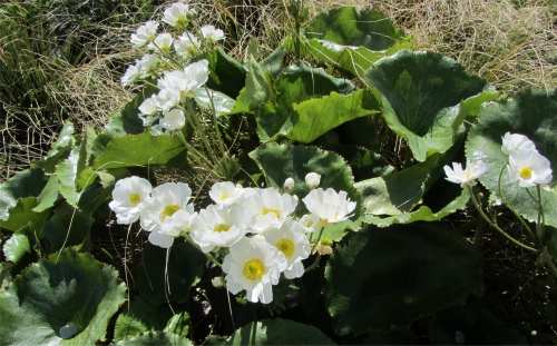
Mount Cook Buttercup
|
I ventured a short way from the village to the tiny outpost of Arthur's Pass, 924m above sea level, just for the sake of standing there and gawping at the stunning scenery, and to pay my respects to the Arthur Dudley Dobson memorial which crowned the summit of the pass. From here it was only a 30km drop down to Kumara Junction by the Tasman Sea, but I would be taking the long way round via the south of the island to reach that point in a few weeks.
Quite close to this point was the start of the Temple Basin Track, which led to ski fields high up in the mountains. I stocked up my backpack, donned a fleece since it was chilly on the pass due to the winds being funnelled at speed by the mountains on either side of the pass, and started the climb.
Boy, was it a climb, with no respite at all. I overtook a trio who were engaged in a botanical field trip, busy examining minute plants, making lists and notes. I left them to it, and 300m further on I came across a sheet of paper held onto a large rock by a smaller rock. The scribbles appeared to be in Latin, and I guessed that another botanist had spotted some special plant worthy of informing others who passed.
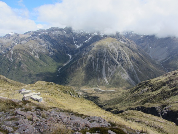
After an age, I spotted the ski huts, and after half an age I reached them. I was absolutely sweltered; it was certainly warmer up here than down in the valley. I paused to look around me. The park straddled the Great Divide, the "back bone" of the South Island; the transition between the wet west and drier east zones of the island, and as a result offered different vegetation on the forested slopes. Travelling up from the east, the forests in the park were almost entirely mountain beech, but on the west of the divide there would be luxuriant rainforest offering greater diversity in the form of beech, podocarp, kamahi and kaiwakawaka.
Mount Rolleston on the Great Divide Lost in the Clouds, the Great Alpine Highway far Below
Notice Cloud Build Up on One Side of the Divide
|
The landscape also varied across the divide. The eastern side of the park was characterised by wide, braided, shingle-filled riverbeds. The western side of the park had deeply gorged rivers. Down the middle of the Great Divide was an alpine dreamland of snow-covered peaks, glaciers and scree slopes. The park included many peaks over 2000m, the highest being Mount Murchison at 2400m. The U-shaped profile of many valleys indicated glacial action in times long ago. Nowhere else in New Zealand offered more direct access to 360� panoramic views of countless snowy peaks marching into the distance.
I ventured into the large wooden hut, basically one large hexagonal room with windows facing out towards the valley. It was devoid of anything but a bench that ran all round the inside, and a single old mattress in one corner. A voice came out from another corner, "Hello!" It was Bill who was just finishing his lunch. "You're wearing too much clothing," he said. I peeled off my fleece, and collapsed down onto the bench near him. I too started devouring my lunch of dried apricots, an apple and a biscuit, plus a couple of bottles of water to start with. Bill had lived in Devonport for 17 years, across the harbour from Auckland. Originally he came from Hartlepool. I ribbed him about the Hartlepool Monkey, which he took in good spirit. For those who don't know the story, during Napoleonic times, a French frigate was found floating off the coast of Hartlepool. The only inhabitant was a monkey. Now folk from Hartlepool had never seen a Frenchman before, nor had they ever seen a monkey. So they arrested this "Frenchman", took him to court for a hasty trial, found him guilty of being the enemy, and hung him. A true story.
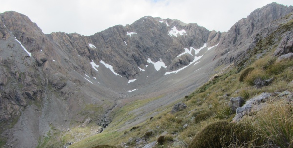
Mount Temple
|
He could detect my northern twang, and asked where I came from. "Whitehaven originally," I said. That jogged his memory, "I once went across to visit Whitehaven, I had heard it had many fine Georgian houses and a lovely harbour. For some damn silly reason, I arrived at Workington instead, totally by mistake. Well I tried to find the harbour there, and ended up in a council estate where every other person had a pit bull terrier. I tried to talk to one fella, but I couldn't understand a word he said. It was one almighty dump." "That was a pity you missed the town. It is the only place in Britain that has been attacked by the Americans," I said. He had already heard about John Paul Jones. I added, "Workington went down the tubes when the coal and steel industry finished. There is nothing else left there now. Mind you, Whitehaven hasn't got a lot to offer now regarding employment, and it has run downhill since I was a lad."
He continued, "Mind you, the last time I visited Hartlepool I was upset to see the way it has gone. There used to be rows of terraced houses where communities lived. The council have torn them down and replaced them with bungalows. The crime prevention scheme they have introduced is a maze of high wire fences around the streets, with gates to provide access to those who have keys. On the top of the gates there are rollers covered in anti-thief grease. It is a crying shame. I'd never go back there now."
|
|
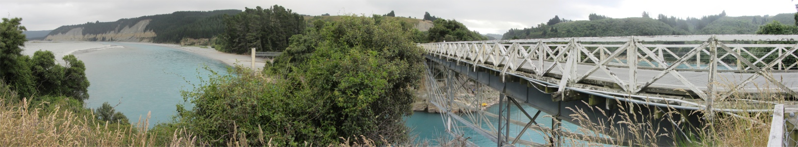
Bridge Over the Rakaia River (please use scroll bar)
|
Bill had to leave, the sun was high in the sky, and it didn't agree with him, so he grabbed his stick, we exchanged farewells and off he disappeared down the slopes.
I had now recovered from my climbing ordeal, and being a glutton for punishment, decided to proceed further up the ridge to get an even better vantage point and hopefully get a photo of Mount Rolleston across the valley. I climbed up a ways until I reached an elderly lady who was sitting on a rock. She was one of the botanist crowd, though she referred herself as being a pseudo-botanist, a latecomer to the field, and I guessed she was more into the social scene than the botanical scene. She too was waiting for the clouds to roll back from Mount Rolleston so that she could take a picture.
I learned that there were probably 20 or so botanists on this field trip, scattered all up the Temple Basin area. They all belonged to a botanical society in Auckland, and had a field trip one a month. Once every two years they ensure a field trip is held on the South Island. They collected data on the variety of species, and abundance, the type of terrain that existed around the plant life, and produced in house reports, plus put some data onto their website.
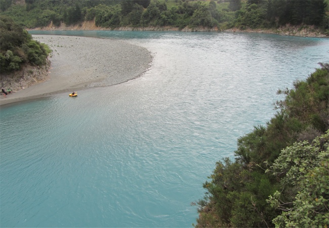
Rakaia River, Deep and Blue
|
I noticed they all appeared to be well past their three score years, and I learned one old lady was into her fourth score. I have nothing against old folks, I am old myself. However I was perplexed as to why there were no younger folk in this botanical society. "Excuse me," I said to one of the old ladies, the one who left Britain 25 years ago, "I can't help but notice that you have a shortage of young blood amongst your team." There was a sharp intake of breath from the two who were sitting near me, perhaps I had been too indelicate, then a warm smile issued. "We did have a young girl who studied botany at university, and she joined bringing a load of her university friends with her. Sadly, they were all made redundant, and moved on. Yes, we are short of young people. Botany is one of the subjects that universities have dropped. Ecology now steals the limelight, and ecologists don't need to know much about botany." The crowd enjoyed themselves, and for some it was definitely more the social networking than the botany that held them all together. They were now all coming off the mountain and slowly making their way back down to the bottom.
I stayed behind for a while, enjoying having the mountain to myself, and waiting for the clouds to roll away from Mount Rolleston. I observed that the mountain sat on the actual divide. It, and all the peaks to the west of it had their crowns cloaked in cloud. However, immediately to the east, all the peaks were visible, bathed in bright sunlight. The abruptness of the change on either side of the divide was remarkable, it just had to be seen to be believed. The clouds never did clear away, so I too made my way back down, overtaking most of the botanists on the way. I'd had an enjoyable four hours up on the alps.
I looked at my maps. I had an option to stay another day, and perhaps do a major hike, or move on towards Mount Cook. The latter had more exciting landscapes, so I decided to spend more time there. However, it would be a 400km drive, and it was already tea time, so I made an instant decision, I would drive part way and hopefully reach Geraldine and stop over there.
Decision made, I set off for a long drive back as far as Sheffield before taking the scenic SH72 across country. I really hammered the car, and was fortunate that a van in front of me got stopped by the police for speeding. They were too busy with him to bother about me. Further on, flashing headlights gave me and others prior warning that another police car was lurking in a side road.
The roads through the Canterbury Plains were predominantly long and straight, so I made good time. This route passed down along the South Canterbury foothills, the boundary zone where the flat Canterbury Plains started their climb up to the Southern Alps. This route also went by the name "Inland Scenic Route". The journey took me over the Rakaia River, under which turquoise waters spilling out of the Rakaia Gorge, fanned out into yet another braided river, and I soon found myself traversing the flanks of the Mount Hutt ski-field, widely regarded as the best and most developed ski and snowboarding field in the southern hemisphere. Passing by the Awa Awa Rata Reserve, I spied tall mountain beech and snow tussock. The Southern Alps to my right were now just shadows behind a curtain of mist. Passing to the east of the 1687m Mount Somers, I encountered areas of bog.
I reached Geraldine, got into a campsite, and just headed straight for the showers. I was whacked from both my hike and all the driving, so it was a case of write up some of my blog, and before long I was soon asleep.
|
Uploaded from Holiday Park Campsite, Geraldine on 7th January at 10:10
Last updated 8.1.2012
|