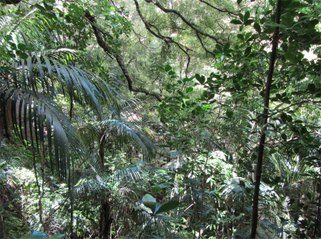
new_zealand_banner
...... previous day next day ......
Whangarei Bay of Islands

7th December 2011

A Meeting with the Giant Kauri, a Climb to the Gods, and a Stroll along by the Ocean

native_bush
Native Bush
    Most of my morning was spent catching up on my blog, and totally arranging the interior of my deluxe home. I had slept well, but the storage needed a total revamp.
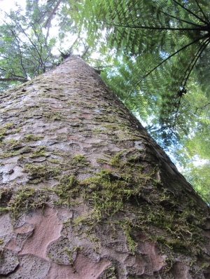
kauri_in_reed_memorial_kauri_park
Kauri Tree
    Once done, I headed up to the A. H. Reed Memorial Kauri Park, named after A. H. Reed, a well-known New Zealand author, publisher and long distance walker. Here a shady path wound its way amongst native bush: giant ferns with bark of similar texture to the pictures I used see of pre-historic forests as a child, variations of the palm tree family, and other trees that seemed to act as home to a host of smaller exotic bushes that grew where ever they could get a foothold in the bark or branches. A feature of the trail is the canopy walkway over the Wai Koromiko stream, which provided me with a bird's eye view of the forest. Perching lilies and hanging ferns clung high in the nooks and niches. Plants with wild names such as lycopod, spleenwort, pittosporum, kowharawhara and kahakaha lurked amongst the dense foliage. Lichens, moss and orchids were to be found in abundance too. Towards the end of the canopy I was passing through a magnificent remnant of the original kauri forests past 500-year-old trees, a typical stand of kauri rickers (juvenile trees), which were once extensive throughout Northland.
flowers_in_bush
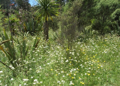
Wild Flowers among Native Bush
    I didn't realise it at first, the placards along the way were not at all clear, and when I came across a trio of trees of massive girth, I presumed them to be kauri, but wasn't sure. A young couple passing by were not sure either. The bark of these trees was nothing like any I'd seen before, and it was totally different to the bark on the Giant Sequoias and redwoods I had seen in California. The surface of the trunk looked dimpled as though it had been beaten with a large ball hammer. Its surface was difficult to score, and to strike it was like punching concrete. This was a living hardwood I was eyeballing. I spotted little trails of resin or gum, and they convinced me that these were indeed kauri. I felt privileged to stand among these noble giants. As A. H. Reed stated in 1952, "A noble stand of Kauri of which the largest surpasses any of its kind so near the town. They have been growing side by side for hundreds of years and may be expected to do so for hundreds of years to come."
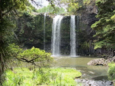
whangarei_falls
Whangarei Falls
    Satisfied I had met these grand old men, I branched off to pick up the Hatea River. An easy stroll up stream took me along the river flats passing through open pasture land and tracts of wild flowers, and past a herd of cattle sheltering from the glaring sun under a clump of trees. Structures provided evidence of early settlers' activities and interests. I broke out of the lush bush at the foot of the Whangarei Falls. Here a curtain of water cascaded over a 26m basalt ridge into a popular swimming pool at their base. The setting was quite spectacular, the rain forest providing the perfect frame.
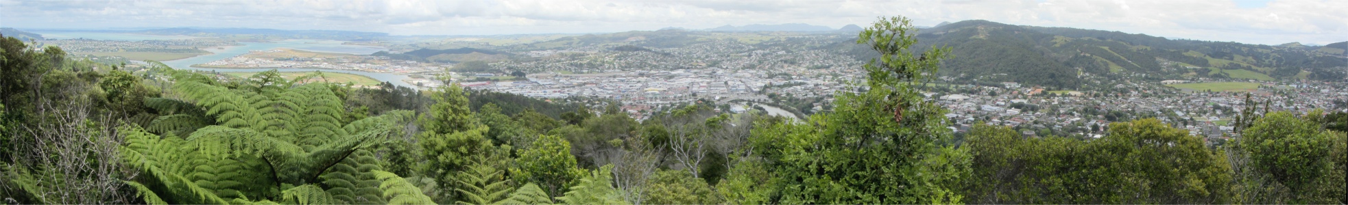
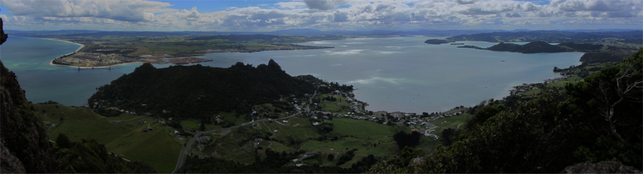
    By the time I returned to the car, I felt as though I'd had a good walk. My next stop was the lookout at Mount Parihaka, a volcanic dome rising 241m to the northeast of the city centre. It is about 20 million years old, and part of the Harbour Fault which also includes Parakiore near Kamo, and Hikurangi near the town of the same name. The dome is surrounded by the Parihaka Scenic Reserve. From here I was afforded splendid views over the city and out across Whangarei Harbour. A War Memorial at the summit commemorates New Zealand's fallen during both World Wars, providing a sober reminder of these young men who went off to the opposite ends of the earth to sacrifice their lives for the motherland.
View from Mount Parihaka Looking Down towards Whangarei Harbour and the City      (please use scroll bar)

mount_manaia
Mount Manaia
    The only thing left on my agenda for today was to travel out across to Whangarei Heads. The road followed a circuitous route around the jagged volcanic outcrops defining the northern reaches of Whangarei Harbour, passing mangroves, pohutukawa-lined bays, scattered beach communities with neat gardens, and the occasional old fellow pushing an old-fashioned lawnmower. Gentle waves lapped the shores, and distant headlands and islands floated on a turquoise sea. I wondered how long Cook and his crew stayed in Bream Bay.
    I made a short detour across to Pataua on the north side of the Heads, just to get a flavour of how the land lay there. This unique coastal community is split by an estuary and joined by a footbridge. I was more impressed with the estuary than the land.
    Once back on the main road to the Heads, I rounded a bend and saw a sign pointing to the car park for the Mount Manaia trail. I met a chap as I parked, the proprietor for the Mount Manaia Club, and asked him, "Have you got any information on the trail?" "No, but there is a sign a short distance along the trail," he replied. "Your calves and buttock muscles will be shredded after climbing all the way up there. It's all steps," he added as encouragement. I laughed, I wouldn't be put off by that sort of talk, and so I went up, straight up. This majestic rocky outcrop towers 460m above Whangarei Harbour, dominating the skyline, and was 460m of purgatory. I gritted my teeth and got there. The view was worth it. I looked across to Ruakaka Beach, then down onto Marsden Point, New Zealand's one and only oil refinery. But the piece de resistance was gazing up the length of the Whangarei Harbour. I was up alone with the Gods here, nobody else was mad enough to tackle the climb. In times gone by, Maori used to bury their dead chiefs among these rocks, and much of the area is sacred and off limits.
View from Mount Manaia Looking Across to Marsden Point and up to Whangarei Harbour      (please use scroll bar)

    One Maori legend says the five key rock formations at the summit represent five people - the paramount chief Manaia, his two children, Pito the beautiful wife he mischievously stole from the chief Hautatu, and Hautatu in pursuit brandishing his mere (stone weapon) ready to strike his wife down. The figures were all turned to stone as the God of Thunder spoke from the skies. However, as usual there is another legend with a slightly different twist, but I shan't bore you with that.
    I made my way down in half the time it took to climb, and headed across to Ocean Beach, the end of the road. The beach was a wide stretch of sand, hedged in by sand dunes. Unlike the sleepy inner harbour coves, the Pacific gave this beach an energy of its own. Surfers paddled their boards out across the surf, hoping to catch the perfect wave, but they were sadly lacking today. The sun, surf and salty air provided the perfect antidote to the lung busting climb I had just endured.
ocean_beach
Ocean Beach
    Before boredom set in, I began the long drive back to Whangarei. I had done quite a lot of hiking today, and I needed calories to replenish my energy levels. I returned to Reva's in the Town Basin, and ate a delicious Thai chicken salad, before returning back to base to enjoy a cool beer out of my on board fridge.


...... previous day next day ......
Whangarei Bay of Islands

Uploaded from Top 10 Campsite,Mair Road,Whangerei on 8th December at 08:10

Last updated 10.12.2011