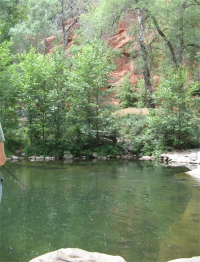
Oak Creek Canyon Pool
|
I woke up to a warm, sunny morning, which was quite typical in Arizona I suppose, and went through the usual washroom and breakfast rituals. Today was going to be tinged with sad memories from a far off place, and even before arising I was feeling guilty that today, of all days, should have been spent with my children. I was sure they could cope admirably without me as they always do, but even so the guilty pangs were there. It was doing me no good moping about it, so I jumped in the van and headed down Highway 89A in the direction of Sedona.
The route took me down Oak Creek Canyon, a serenely breathtaking stretch that attracted a wide array of travelers each year. Noted for its scenic splendor, Oak Creek Canyon lay within the Coconino National Forest between Flagstaff and Sedona. The canyon itself was about fourteen miles in length and was carved by the creek. It sat on the southern edge of the Colorado Plateau. Less than a mile wide from rim to rim, the canyon's deepest point lay about a mile and half from the top of the rim. The canyon opened up to the vibrant foliage of oaks interspersed with evergreen pines, and the incredible red-faced rocks and cliffs provided the backdrop.
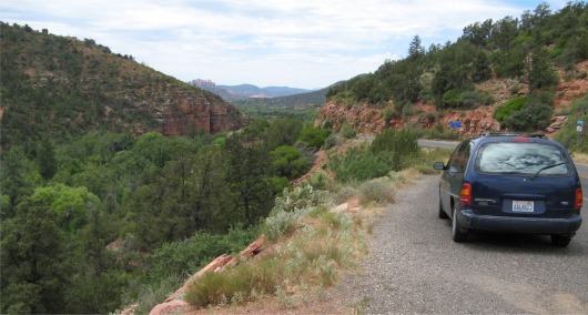
Leaving Oak Creek Canyon and Heading to Sedona
|
Sedona occupied a delightful location among the red-rock canyons and wooded hills. Water and fertile land attracted farmers in the late 19th century, and it was the provisioning centre for Jerome during the mining boom. Today the popular resort has the reputation as a centre for New Age living. In 1981, the psychic and writer, Page Bryant, identified seven vortexes in the area, which she believed emanated electromagnetic energies that invigorated the soul. The subsequent influx of "New Agers" was followed by hordes of tourists. This was all reflected in the psychic healing centres, crystal vortex centres, crystal, jewelry and gift shops, plus numerous up market boutiques and galleries. People who I had met and talked about Sedona told me it was expensive. They were all correct.
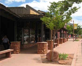
Downtown Sedona
|
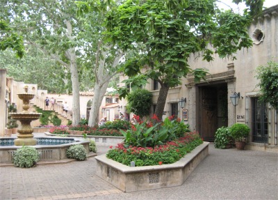
Tlaquepaque
|
Down towards the creek lay Tlaquepaque, a small complex built to resemble a Mexican village. It was full of galleries and up-market restaurants and boutiques. I found the number and diversity of galleries in Sedona very stimulating, and I spent the best part of two hours wandering around the various galleries and having chit chats with the owners.
From Sedona I continued my trek to Tuzigoot National Monument. This citadel was perched on a solitary and slender limestone ridge offering splendid views of the Verde River Valley. The pueblo was built by the Sinagua people between the 12th and 15th centuries, and at its peak housed perhaps 250 people in its 110 rooms. It was abandoned in the early 15th century, when it was believed the Sinagua migrated north to join the Ancestral Puebloans. The most unusual feature of the pueblo complex was the lack of doorways. Each room was entered through a hatchway in the roof. The roofs were now long gone, but they would have been much appreciated since recent rain had encouraged a plague of flying ants to descend on the place. I learnt that this was Arizona's monsoon season. The visitor centre contained a number of Sinaguan artifacts on display. It also displayed a temperature of 106 deg. F!
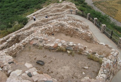
Some of the Tuzigoot Dwellings
|
|
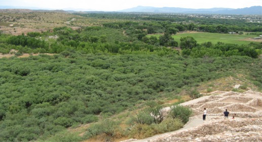
The Lush Verde River Valley
|
|
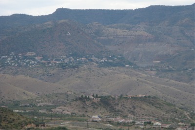
Jerome Clinging to Cleopatra Hill - Notice the Large White J on the Hill
|
Across the lush Verde River Valley I could see the town of Jerome clinging to the hillside, and nearby on the valley floor, orange areas indicated where tailings from the mine had been washed down as slurry into lakes.
Jerome was my next port of call. Its collection of old brick buildings clung to the side of Cleopatra Hill high above the valley. In the 1870s silver mining took place here, but in 1912 the town's big break came when prospectors found a five feet thick vein of copper. The price of copper went sky high two years later when World War One started (munitions require a lot of copper) and Jerome boomed. The prices tumbled during the 1929 Wall Street Crash, but the mines survived until 1953.
Jerome had other issues to contend with. The incessant underground dynamiting had made Cleopatra Hill unstable, and the town began to slide downhill at a rate of 4" per year, with an occasional major slide. During the boom years Jerome boasted a population of 50,000 people, but by the early 60s, it was virtually a ghost town. The low price of property attracted an influx of artists and artisans, whose galleries and stores attracted tourists by the score.
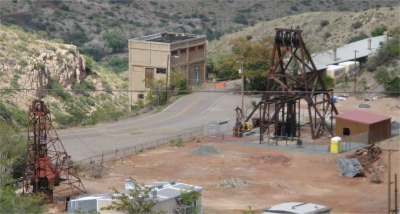
Mining Relics from Jerome's Past
|
I wandered through the old town, spotting the remains of some mine heads lower down the hillside, the old primary school, and old hotels, bars and one-time brothels. I couldn't resist visiting the numerous galleries, and I came across one chap who was throwing pots in an outhouse just below his two-story gallery. He had been a potter for 37 years, but 10 years ago took up glassblowing too. He showed me the coloured glasses he bought in, in order to stain his pure glass which he bought by the ton. For the coloured glass he paid up to a couple of hundred dollars per kilogram for some of the colours. All coloured glass was now imported from the Czech Republic or New Zealand. Indeed all the glasses and associated glass blowing tools had to be bought in via Washington State. I had an interesting chat with the guy for some time until more folk turned up and he was obliged to throw another pot. Jerome had a similar history to Butte, but had managed to turn itself around into a thriving tourist attraction, mainly for the arts rather than the mining.
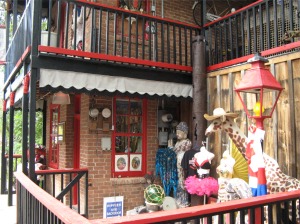
Jerome Arty Crafty Shop
|
|
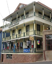
Central Hotel
|
|
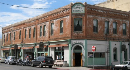
Hotel Conner
|
|
From Jerome, I drove over the Mingus Mountain and down a long valley to Prescott. I arrived in the centre of Prescott, but by this time it was too late for sightseeing, I needed to find somewhere to stay for the night. I asked a couple where the campsites were, and I got a confused story about camping by a lake. The lady mentioned all sorts of street names, which went right over my head since my familiarity with the town had been limited to five minutes. However, she did mention the name of a big store on the outskirts of town where I should turn off to the lake. Totally bewildered, I headed out of town along the road I would need to take tomorrow. By pure chance I saw the big store she had mentioned, and a sign pointing to Prescott Lakes recreational area. I shot down the road a mile or two and did find a campsite by the Lynx Lake. I was mightily pleased. I drove around the site and managed to find the one and only space left.
I needed some fresh air, so I took a walk down to the lake which would have been teeming with water sports during the day, but now only had a couple of canoeists paddling along the far shore. It was good to smell the pine after a downpour again. After a leisurely walk back from the lake, I cooked a chicken chowder, enjoyed a couple of warm beers, and that was me done for the day.
It had been a funny old day for me, but I kept myself on the go all day to prevent myself from brooding. I just needed a good night's sleep.