I made a leisurely start to the day, and just as I was about to leave the camp warden popped by, the same lady I had been talking to the evening before. She asked me where I was off to today, and I told her I was moving on to Zion National Park. She commented that it would be crowded there. I asked why more so than Bryce. She pointed out that Bryce is much further to travel. Zion, on the other hand, was close to the Interstate Highway, within easy access from Las Vegas and St George. I told her I was having difficulty with the heat, and she advised that although the altitude at Bryce should give a temperature of around 75 deg. F, the thin air combined with the sun made it feel warmer.
She then went on to discuss her Lancashire roots. Her grandfather had been a cobbler near Preston, then her father worked at Barrow-in-Furness in Cumbria for a company making large cranes. The company wanted to expand into America, so he was sent to build up an American counterpart, which he did quite successfully. The lady was only 18 months old at the time. However, his heart was broken when the company was eventually sold to an American firm. The lady still kept in touch with her roots via the internet, and hoped to visit in the next couple of years. I insisted she should, and we parted laughing.
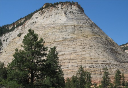
Checker Board Mesa on Zion-Mount Carmel Highway. Horizontal Bands
marked Old Sand Layers, Vertical Bands were Erosion Cracks
|
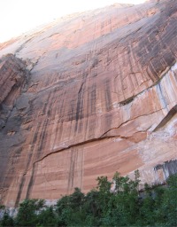
I had one last look at the hoodoos from Sunset Point, and then headed off, passing down through Red Canyon with its two arches, and a few hours later reached the east entrance to the park. The drive down to Zion Canyon over the Zion-Mount Carmel Highway was over rough roads due for resurfacing soon, but the views were spectacular. Two tunnels had to be passed through; major engineering feats in 1930.
My first action was to find a camp pitch, and there were only two campsites, both by the visitor centre. I drove up to the Watchman site first, but was turned away at the gate because it was full. However, I was advised that the South Campground still had spaces, so without delay I headed straight there. After a short drive around I found a suitable pitch and I was a happy man.
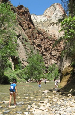
Entrance to The Narrows
|
Zion National Park is a national park located near Springdale, Utah. A prominent feature of the 229-square-mile park is Zion Canyon, 15 miles long and up to half a mile deep, cut through the reddish and tan-colored Navajo Sandstone by the North Fork of the Virgin River. Located at the junction of the Colorado Plateau, Great Basin, and Mojave Desert regions, the park's unique geography and variety of life zones allow for unusual plant and animal diversity.
Zion was the middle-aged park that sat on the Grand Staircase, older than Bryce Canyon's crenellated edges, but much younger than the lowest rung, Grand Canyon, into which 90% of Colorado Plateau waters run. Zion's gathered waters, known as the Virgin River, traverse Mojave Desert lands and join the Colorado River in Lake Mead's handmade basin before completing their Pacific-bound journey.
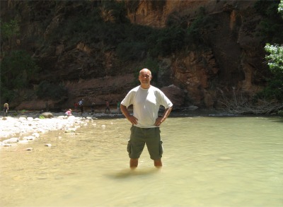
A Refreshing Paddle in the Virgin River
|
I was feeling good, and whatever bug I had suffered over the last couple of days seemed to have passed away, so without delay I checked out the various trails within the canyon, and decided to start at the very top end with the Riverside Walk, an easy riverside trail along the North Fork of the Virgin River, starting from the Temple of Sinawava. The way through the canyon was by free shuttle bus only. These ran every 7-8 mins, and stopped off at key points along the valley. This was a highly sensible arrangement, there would not be enough room on the narrow road for all the cars and RVs that would otherwise parade up and down, and there certainly would not have been enough room to park them all. As the bus travelled up the valley, I was struck by how this valley reminded me of Dovedale in Derbyshire. It was a much grander scale of course, and the rocks were predominately red, not white, but it was as lush as Dovedale.
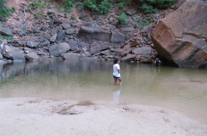
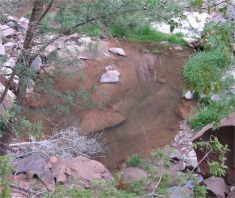
The hike along the river was a tester to see if really had recovered, and it was no problem. The walk petered out, and then the only way to proceed further was to walk up The Narrows, basically walk up the river as the canyon walls closed in. I didn't want to ruin my trainers so I forewent that option. I met a young guy later who went up and back covering 17 miles, and he was whacked. Instead, I wandered back down the river and stopped off to have a refreshing paddle. There I met Eli and Alison and their two small children. Eli obliged by taking my photo, and we got chatting about travel, and how we used to hitch-hike when we were younger, but nobody dare pick up hikers now (I reckoned I was hitch-hiking before they were born). I also talked about the Grand Canyon with them, and how I was going off the idea of walking down and back. They told me about a group who went down from the north rim and came up on the south rim; basically they started at 11pm and they finished at 11am the following morning, but by then it was already too hot. I protested that you wouldn't be able to appreciate the beauty of the canyon by hiking at night, but apparently the group had done it under a full moon, which they reckoned was just as spectacular. Hmmm..... not entirely convinced, and besides when I arrived at the Grand Canyon, the moon would be in the opposite phase. Eli was a fit guy, he did a lot of mountain running, so I explained the art of fell running to him. I said I intended doing the Angels Landing hike the next day; he was going to run most of it apart from the sections where you need to climb. Good luck to him. A nice family. We parted, but also bumped into each other later in a drinks line.
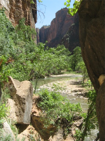
Lush Zion Canyon, almost like Dovedale
|
Invigorated by my paddle, I headed down to Weeping Rock to tackle the short but steep trail up to the rock. Basically this was an overhang, with a layer of shale a short distance up from the overhang. Similar to Mesa Verde, when water seeping through porous sandstone hit a layer of shale, it would move out sideways and "weep" out of the cliff face. Here there was a lot of weeping going on, and a curtain of 'rain drops' was falling down from the overhang. Tests had been done on such weeping waters in Zion, and the age of the water ranged from 1,200 years in some areas, to 4,000 years in others. It was refreshing to lean out and have a shower in the ancient waters.
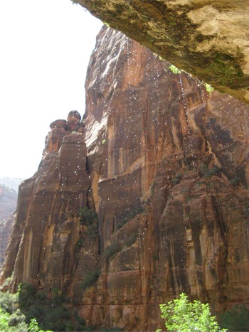
Water Dripping from Weeping Rock
|
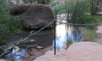
Still feeling full of beans, I decided to hike the Emerald Pools Trails; basically there were Lower, Middle and Upper Emerald Pools to be seen inside a box canyon off to one side of the main canyon, with very high vertical cliffs. It was a steep climb over a reasonable distance, but this side of the canyon was now in shadow as the sun settled lower in the west, making it a pleasanter trek. Half way up, there was a cliff edge with a chain link fence preventing folk walking off the edge, and a sign saying "Do Not Enter" that was so faded it was almost useless. I had a laugh about it with a chap standing next to me, and he was British, so we started talking. His wife ambled over, and within a short space of time I discovered that the couple lived in Holbrook, a village just few miles south of Ipswich, where I lived. What a small world. Peter and Deborah Bush were doing a lightening three week trip around the Southern Utah/Northern Arizona areas, the so called Grand Circle, and our itineraries would be fairly similar. I was able to advise him on the Glen Canyon and Bryce Canyon areas and what to take in. Sad to say Deborah also suffered from the heat, so I explained she was going to have a tough time. We saw the Emerald Pools together, discussing news from back home, families, travel and other trails to tackle in Zion.
The Upper Pool was impressive; a sandy beach shelved into an inviting pool which was emerald at the far end, probably from algae. What made this location stupendous were the mighty sandstone cliffs that soared high into the skies all around the pool, with water weeping down from a short distance up.
The Middle Pool was more of a puddle fed by a running stream from the Upper Pool. The puddle definitely was covered in green algae.
The Lower Pool further down was definitely a pool, but more sandstone coloured.
Upper Emerald Pool
|
|
Middle Emerald Pool
|
|
Lower Emerald Pool
|
|
Vertical Cliff by Upper Pool
|
The hike was well worth it though, and it was good to have an extended chat with Peter and Deborah. We wished each other a safe trip, and joked that we probably might meet up at one of the evening talks laid on by the rangers.
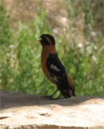
Small Bird at the Bus Stop
|
I caught the shuttle bus back to the campsite, and got chatting with Ron Newman, a chap who lived in Bedford. He was a fellow in his mid 60s who had been traveling to America once or twice a year since 1994, and still found plenty to discover; he found travel in Europe was limiting due to the language barrier. He had flown to Denver, had taken in Mount Rushmore, the Bighorn Battlefield, Grand Tetons and umpteen other places and was now in the Grand Circle area too. He had a major set back on this trip though, an abscess on a tooth had set him back a pretty penny and wiped out a few days of his trip, but he seemed to have taken it all in his stride, and was now cramming it all in before wending his way back to Denver. Ron had trained as a fitter at Ipswich Cliff Quay Power Station (what a small world again), and with the skills acquired, went on to travel the world doing similar work before the third world learned how to do things for themselves. Our journey came to an end, and we exchanged contact details before we shook hands and left in opposite directions.
The National Parks often ran Ranger-led Programmes, and Zion was no exception, in fact it was exceptional. Each day from 08:30 until 22:30 there were continuous walks and talks, and the talks were on many diverse topics, for both adults and children. I strolled down to the Watchman campsite auditorium for the 21:30 talk, which turned out to be on the night skies. This was a relevant topic since the National Parks had formed links with the Dark Earth Society to minimise light pollution. The talk lasted an hour and was delivered by a girl who had been a seasonal ranger for seven years, and also had an interest in astronomy. It was very informative and kept both young and old enthralled for the duration. To conclude, she switched off all lights, and with a laser pen pointed out the various constellations in the sky, including a satellite that was whizzing overhead. Zion Canyon was an excellent place to view the heavens, and since the shuttle buses ran until 11pm, one could still travel up the canyon a way to observe the heavens.
A lovely way to wind up the day I thought, and I glanced at the heavens as I picked my way back to my own campsite.