I pulled into Cortez Safeway store to stock up on non-perishable provisions; I had given up on fresh food since it wouldn't keep in the heat. Whilst in the store I noticed they had a delicatessen, and nearby a few tables and chairs. I thought I'd supplement breakfast with a tub of salad. Behind the counter was Norman, a jovial coloured fellow who originally hailed from Illinois, but had moved down to Colorado for a change. When I asked him for a tub of salad, he burst into fits of laughter. When he saw the puzzled expression on my face, he asked, "Hey man, are you from Australia?". "No", I replied, "I'm from England". Peels of laughter again emanated from Norman, "Ah, England, Australia", he replied in complete earnestness. "No", I said, "England is not in Australia. It is a country at the opposite side of the planet to Australia". I could see the cogs whirring while he took this in, then he burst into more fits of laughter because he had screwed up.
He then associated my accent with the film Braveheart. I said I was born within 50 miles of Scotland, and he was beamingly happy with that. Whenever I said anything he burst into more laughter, and it was contagious; I couldn't help but like the man. "Do you know Benny Hill?", he asked. I said I had never met the man, but I knew of him. Norman was an avid fan of Benny Hill. Indeed quite a few Americans love old British comedy. Norman sussed out I was doing some traveling, and he had an ambition to travel also. He was now 40 and hoped to travel soon. I thought that with the standard vacation allowance, he would be hard pushed to make it around Colorado. I bade Norman farewell, and I could still hear him chuckling away as I walked to the exit. I had made his day somehow.
I continued my journey somewhat concerned. I had two sets of maps and one was indicating one of the roads to take would be paved, whereas the other listed it as graded (gravel). It was well into the 90s when I arrived at the Hovenweep National Monument.
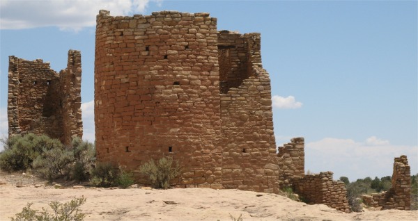
The canyon and mesa country north of the San Juan River holds many archeological sites where ancestors of today's Pueblo Indian tribes lived. Round, square, and D-shaped towers grouped at canyon heads most visibly mark once-thriving communities. No one has lived in them for over 700 years, but they are still inspiring.
Many dwellings stood right on the canyon rim, and some structures were built atop isolated or irregular boulders; not practical sites for safety and access. Most were associated with springs and seeps near canyon heads. Such locations suggested that the ancestral Pueblo people were protecting something, if not themselves, then perhaps the water.
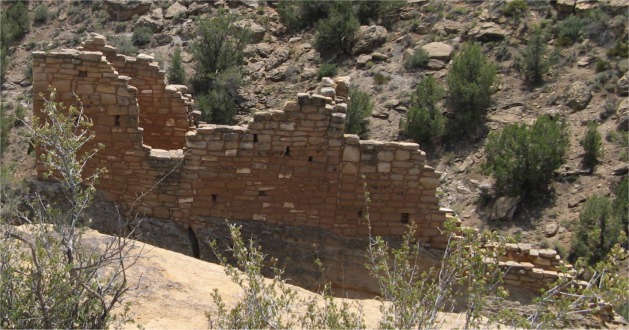
At Hovenweep, population density varied through time. In the late 1200s, increasing numbers of people concentrated at the heads of small canyons, where they built pithouses, pueblos, kivas and the towers that are Hovenweep's trademark. Most of the buildings still standing were constructed from 1230 - 1275, about the same time as the cliff dwellings at Mesa Verde. The stunning Square Tower and an intriguing collection of buildings were clustered along Little Ruin Canyon. But the Square Tower community was not alone. 700 years ago, a lively system of settlements flourished in the immediate area, all within a day's walk of each other.
The Square Tower group was located in the heart of a 500 square mile raised block of land called Cajon Mesa and was part of the Great Sage Plain. Several streams drained the mesa and flowed into the San Juan River to the south.
Pioneer photographer William Henry Jackson (the guy who photographed the Grand Tetons), who came here in 1874, called this place Hovenweep. It was a Ute/Paiute word that meant " deserted valley". The fine state of preservation of the structures and their unusual architecture led to Hovenweep's designation as a national monument in 1923.
Ruins were scattered over a vast area, but I opted to walk the Rim Trail and Tower Point Loops. In the heat, that was sufficient, and would give me a good feel of the monument. I set off, noting the warnings that rattlesnakes resided in the area.
|
|
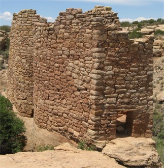
Together, the Twin Towers had sixteen rooms. Their architecture was amazing; the two buildings rose from the native bedrock, their walls almost touching. One tower was oval, the other horseshoe shaped. Their builders had skillfully laid up thick and thin sandstone blocks.
|
|
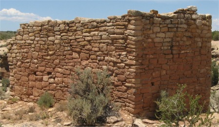
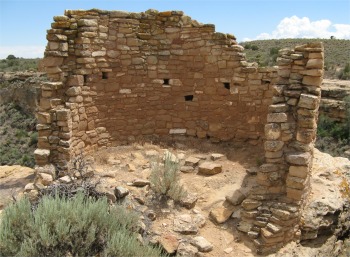
Hovenweep House was the centre of one of the largest Pueblo villages in the Square Tower group. What still stood was built on solid sandstone bedrock. The rest had crumbled to the ground, but a closer look revealed its former size and pattern. As with other buildings in the area, the masons took great pains with their stonework. Some boulders were pecked on the surface, a technique seen at nearby Mesa Verde.
|
|
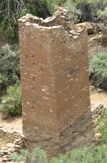
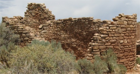
Down in the canyon stood Square Tower, two stories tall. Situated on a large sandstone boulder, it was built in a slight spiral shape, perhaps for added strength or aesthetics.
 Tower Point |
There were striking similarities between the monument and Mesa Verde. Both sites would have experienced the same long drought, which would explain why the inhabitants all departed at the end of the 13th century.
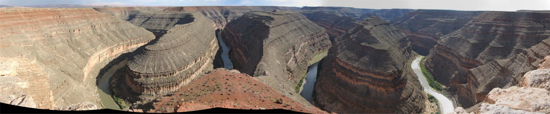
I left sweltering Hovenweep, wondering how they could have survived the hostile environment, and made my way across country to the Gooseneck State Park on the San Juan River.
At Goosenecks, I was presented with a spectacular view representing over 300 million years of geologic history, one of the most striking examples of an entrenched river meander in North America. The solitude, vastness of open space, and pristine beauty of this place was unbelievable.
Approximately 1000' beneath where I was standing wound the San Juan River. Originating in Colorado, this river eventually joined Lake Powell. The silt-laden San Juan had been instrumental in cutting the deep bending chasm directly below. This section was called the Goosenecks of the San Juan River.
Geologists considered this part of the river to be one of the finest examples of "entrenched meanders" anywhere in the world.
The meandering pattern originated several million years ago when the river was flowing on a relatively flat plain, much as the present-day Mississippi River. The San Juan became entrenched when the entire Colorado Plateau was slowly uplifted. Cutting downwards, the river followed its initial pattern and thus created the canyon I now saw.
The process continues to this day as the San Juan River cut ever deeper into prehistoric geological formations.
Geological formations on this scale really ball me over. I could have basked in the solitude in total wonder and amazement for hours, but I couldn't bask in the heat.
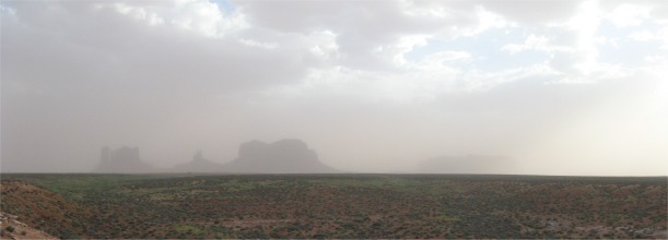
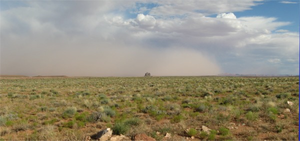 Dust Storm Approaching |
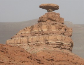
I continued my drive in that direction, pausing to take a photo of the Mexican Hat formation. As soon as I got out of the car I felt a very strong wind and dust and tumbleweeds were hurtling past me. This was my first experience of a dust storm.
I drove on through the village of Mexican Hat, but on approaching Monument Valley, I saw it was shrouded in swirling clouds of dust. It was pointless carrying on, so I turned around to find somewhere to stay in Mexican Hat. Maps indicated a campsite in the village; the maps were wrong.
|
|