I laid in until 7am. It was a bright sunny day with blue skies, but I could still feel the effects of a fierce wind. After a refreshing shower, I met my neighbours who slept in the tent. They were an elderly couple who must have been in their late 60s/early 70s. They were pleased that their tent had survived the onslaught. I learnt they were also touring with their motorcycle and trailer; good for them, there is hope for me yet. They were heavily wrapped up since the vicious wind was cold.
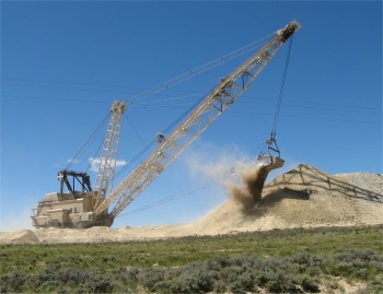 Gigantic Dragline |
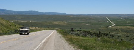
I therefore decided to head east along the I80 and pick up a road south to Baggs, then Craig. The countryside was not as desert like as I thought it was when I arrived the previous night in the pouring rain. Any hills that I passed were low lying buff sandstone affairs. There was a fair amount of vegetation on the ground, mainly grass and sagebrush, though trees were scarce. The road seemed endless, and as I drove over the Continental Divide at one point I was presented with an almost flat wilderness stretching for 40 miles or more. Buildings were few and far between. I did come across a gigantic strip mining dragline in operation, scraping away the top layer of rock and dirt (called 'overburden') and making mountains of it beside the highway. The body of this huge dinosaur looked like a block of flats. It was probably exposing a coal seam, which are fairly prevalent in the area, particularly in North West Colorado. I turned off at what I thought was a suitable junction to take a shortcut across country to the road I needed to be on. However, when I turned off the highway, I soon arrived at a T-junction, with no indication which route to take, so I sought guidance from the garage nearby. The lady told me, " Go another 13 miles along the highway, honey, and turnoff there". I asked her what was wrong with the shortcut shown on the map. "Well, if you want 40 miles of mud and potholes, you take the shortcut". I saw her point. A word of warning to fellow travelers, maps show roads, but give no indication whether they are, as we would say in the UK, A, B, C or Z class roads. I thanked the lady, and returned to the van through the icy and even stronger wind.
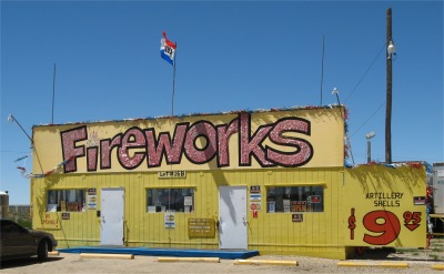 One of Many Fireworks Shops Scattered Around in Odd Places |
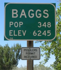 Baggs, Last Town I Passed Through in Wyoming |
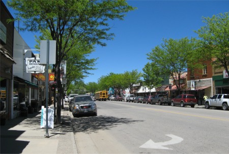
After 3 hours of driving, I reached Craig, a small town with a lovely tree lined main street, which didn't look like a 'cowboy' town. I took a break and had a coffee. This far south the gale had abated to a stiff breeze and it was considerably warmer. This was Colorado.
|
|
As I drove south, the road started to descend over a considerable distance down to the Colorado River. The surrounding vegetation got sparser with the drop in altitude. At Rifle, I headed west along I70 via a gracefully rolling route sandwiched between the Grand Mesa and the hills leading up to the Roan Plateau. A railway and the Colorado River also shared the same route. As the route progressed, the vertical, rocky walls gradually closed in until the road was clinging to one cliff side, and the railway clinging to the other, with the river surging between. I reached my turn off up into the Grand Mesa, and it was a very long climb up onto the plateau. The contrasts were amazing, starting in a desert canyon, and as I made my way to the top of the mesa, I passed aspen foothills, lakes, alpine forests, lily ponds and meadows bursting with wildflowers.
The Grand Mesa is a large geologic formation in western Colorado. The largest mesa in the world, it has an area of about 500 square miles (1300 km) and stretches for about 40 miles (65 km) east of Grand Junction between the Colorado River and the Gunnison River, its tributary to the south. The north side of the mesa is drained largely by Plateau Creek, a smaller tributary of the Colorado. It rises about 5,000 feet above the surrounding river valleys, including the Grand Valley to the west, reaching an elevation of about 10,000 feet (3,000 m), with a maximum elevation of about 11,327 feet (Crater Peak). Much of the mesa is within Grand Mesa National Forest. Over 300 lakes, including many reservoirs created and used for drinking and irrigation water, are scattered along the top of the formation. The Grand Mesa is flat in some areas, but quite rugged in others.
Geologically, the mesa is the result of a hard volcanic basalt layer on its top. This layer, formed approximately 10 million years ago by basalt flows, suppressed erosion compared to the surrounding sedimentary rock layers, which suffered rapid downcutting from the action of the Colorado and the Gunnison rivers. The top layer rests on a thick sequence of Tertiary shale and sandstone known as the Green River and Wasatch Formations. These layers in turn rest on a Cretaceous layer known as the Mesaverde Group that forms a cliff about halfway up the side of the mesa. The lowest layers are yellow and gray Mancos Shale from the early Cretaceous age. The shale continues outward into the surrounding valleys in the vicinity of the mesa, providing a soil base that is fertile for various kinds of agriculture, especially in the Gunnison Valley to the south.
Before settlers came west, the Native American people populated the area of Colorado, Utah and surrounding areas. The Ute Indian tribe lived in the Grand Mesa Area. They called the Grand Mesa "Thunder Mountain" because of how the mesa towers over the valley 6,000' below. In 1776, the Utes guided Europeans through the area. Later, buggy trips lasting several days brought touring travelers to area. Stage lines and freight wagons soon replaced the buggy trips. Improvements on roads in 1911 from convict labor provided easier travel. In 1933 the Civilian Conservation Corps built "Veteran Road" (now Land's End road) that twists its way to the top of the mesa.
I headed across to Collbran to pick up a campsite there for the night, and would also serve as a good starting point for exploration the next day. I reached Collbran, but there were no signs for campsites anywhere. I stopped and asked a group of old timers who were sitting outside a hall tuning their guitars and banjos. They were about to enter the hall to provide the evenings entertainment, but found time to tell me, "Sure can, boy. You just git up that road there, turn right and after 5 miles look for Vega State Park. You can also git food up there at the Lodge". I thanked them profusely, and followed their directions.
I arrived at a Park Rangers Gatehouse; this was a State Park as opposed to a National Park, so I would have to pay $6 to enter. There were five campsites to choose from around Vega Reservoir, which were self registering. To save the hassle, I paid the same amount for a permit, then I could just go find an empty pitch and claim it as mine. I opted for the Island Campground, it was nearest and also quarter of a mile away from Vega Lodge where, according to the Park Ranger, food could be ordered till 9pm. I soon arrived at the Island Campground. It was deserted, I had pick of the pitches. This was a magical setting, a small tree covered island connected by a causeway. The reservoir was a fair size, surrounded by forest clad mountains, idyllic, and it reminded me of the Lake District. At this altitude everything around was lush. The Park Ranger had explained to me that it was the snows which provided the moisture for the tree growth.
Once I was parked, I knew that after almost 300 miles of driving, I didn't want to start cooking, so I headed up to the Lodge. I soon found out that the place closed at 7pm; it was only on weekends that it stayed open late since the crowds poured in. However, the hosts were very kind and cooked me a burrito, which I washed down with a couple of beers. While the lady of the lodge was cooking the food, her husband was out on the veranda, and I thought he was being attacked by some large insects. I went out to investigate, and the creatures were actually humming birds. They were really small, and their hovering capabilities left me amazed. The chap was putting sugar water into feeder bottles so that they could come and feed, which they duly did. We then watched an important final netball game between Boston and Los Angeles, and discussed the World Cup until my food was served. A friend of the couple picked up the UK twang and came over and discussed my trip with me. He was interested and also jealous of the overall adventure, though he had done some of it in dribs and drabs. He also recommended Craig's List, the website to use when it comes to selling the van. A few people had recommended that route. Night time was approaching, and I didn't want to outstay my hospitality, so I paid my bill, thanked my hosts for their lovely food and hospitality, and bade farewell. How very kind they were to go out of their way to host me long after closing time. There are good people in the world.
I walked back down to my island for the night, with a half moon to light my way, and Venus shining brightly just above the horizon. I looked forward to exploring the mesa in the morning.