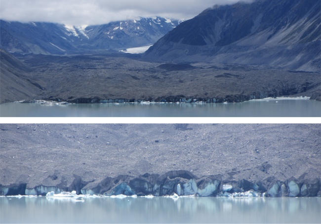
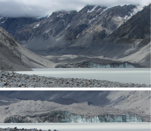
Tasman Glacier Covered in Surface Moraine, Uncovered Towards Rear as it Bends Around the Corner, with Zoomed View Below
To Gain an Idea of Scale, the Ice Wall Where it Meets the Lake is 200m Thick
|
To kill time while the weather developed one way or the other, I made the short trip to the Aoraki Mount Cook Village to visit the information centre. That was a good move. Here I found a stab at a weather report, today cloudy and possibly clearing, tomorrow very cloudy and rain in the afternoon. There was also a wealth of information on the geology, the flora and fauna, and the history of this region. It also served as a partial museum with many fascinating mountaineering memorabilia. A short film show gave an excellent account of those stalwart volunteers that form the backbone of the mountain rescue teams. Part of the film gave the true harrowing account of a climber who had fallen 240m down an almost sheer ice face, and then dropped into a crevasse. It took rescuers seven hours to extricate the victim from the crevasse. Sadly the climber passed away a few hours later in hospital, the 138th victim of Mount Cook. The rescue teams always gather together for a debrief after a rescue mission. The guys who had climbed down into the crevasse had been physically and mentally stretched to their limits, and the death had an emotional impact on them all. However, their courage and sheer determination clearly shone through. My hat goes off to folk like these.
Having enjoyed the information centre, and the mist still hugging the valleys, I walked to the Sir Edmund Hillary Alpine Centre next to the hermitage, which was opened three weeks before New Zealand's greatest hero died at the age of 88 in early 2008. This was dedicated to the Kiwi hero, who used the Mount Cook area as a training ground for his successful Everest assault with Tenzing Norgay on May 29th 1953. The centre also covered his Antarctica Expeditions too. Not only was the man known for his mountaineering exploits, and his humanitarian work in Nepalese villages, but also he was much admired for his embodiment of the qualities most Kiwis held dearly: hard-working, straight-talking, honest and modest. The centre contained a museum covering the geology of the region, together with the mythology and development. Appropriately, much coverage was given of climbing exploits within the surrounding mountain ranges, with material illustrating Hillary's life and achievements.
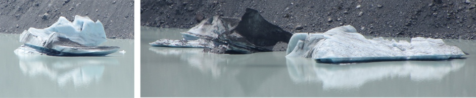
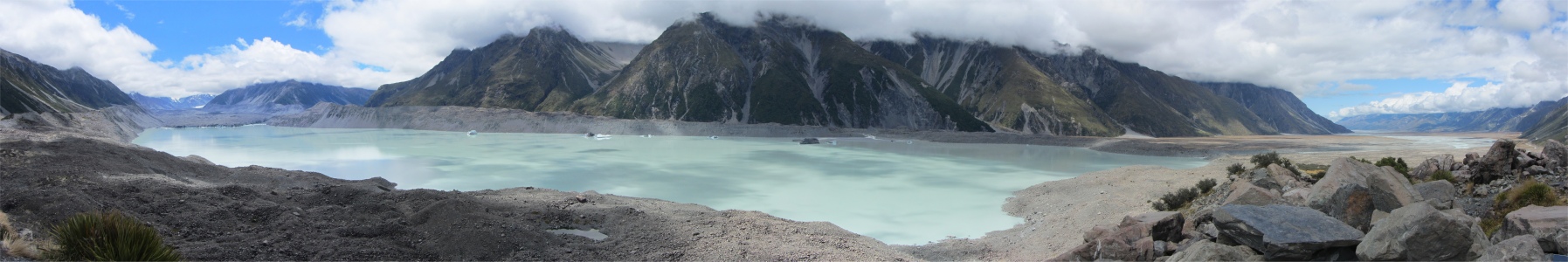
Icebergs on Lake Tasman
|
Hillary always regarded himself as an average bloke. It was the media who built him up in hero status, and he could never shake that off. He was a large man, 6' 2" in height, and large in personality.
Much original equipment was on display, including snow tractors and a full size snow plane used at the Mount Cook airport. A planetarium and 3D movie theatre were also included in the centre.
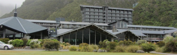
Upstairs in the centre was a cafe/restaurant area, with a huge glass wall facing up the Hooker Valley, what a truly magnificent view. I sipped a coffee and scribbled the notes you are now reading while watching the cloud base slowly lifting. How many coffees will it take I wondered.
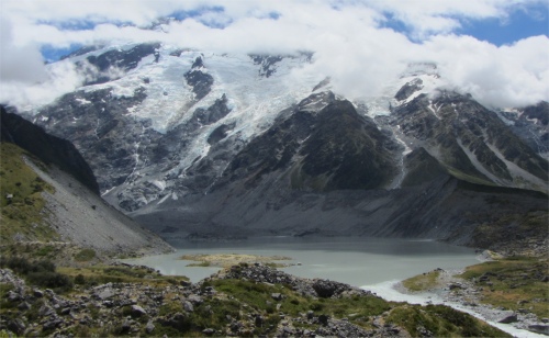
Huddleston and Stocking Glaciers Above Mueller Lake
|
However, the piece de resistance of the area for me was to see and explore the Aoraki Mount Cook National Park. This 700-sq-km park was designated a world heritage site by UNESCO in 1986. It was easy to see why, with a breath-taking army of mountainous peaks. The crowning glory was Aoraki Mount Cook, towering up to 3754m, and New Zealand's highest peak. Aoraki Mount Cook was dazzling, yet there were 27 other mountains in this alpine backbone which peaked at over 3050 metres, and hundreds of others not far short of that, all making up the famous Southern Alps.
These alps were formed 250-300 million years ago in an ocean trench. Then, at the relatively recent time of 2 million years ago, the Alpine Fault began to lift, creating the Southern Alps. The lifting process was still continuing at the rate of 1cm per year, at the same rate as the erosion of the summits.
The Aoraki Mount Cook National Park was alpine in the purest sense, with sky-scraping peaks, glaciers and permanent snow fields; indeed forty per cent of the park's area was covered by snow and ice. It encompassed 23 peaks over 3000 metres high. Mighty monarch, Aoraki Mount Cook, held command over this domain, surrounded by his generals, in particular Tasman (3498m) and Mount Sefton (3157m). Marching down from the upper reaches of this supreme chancel were five glaciers, including the mighty 29km-long Tasman glacier, the largest in New Zealand, and the Hooker glacier. The region was a Mecca for climbers, and was only 44 kilometres from the coast, so storms could arrive suddenly from the Tasman Sea to create dangerous conditions for the mountaineers. Even in summer, the weather could change in the blink of an eye.
Mueller Glacier
|
With the cloud base lifting, and bearing in mind the prospective weather conditions, I wasted no time in heading up to the Tasman glacier. The viewing point was a ridge above Lake Tasman which sat contained by the glacier, the lateral and terminal moraines, a milky lake as opposed to the turquoise colour further down the chain. I put this down to light coloured particles in the water, which settle out long before the blue "flour" particles. What also intrigued me about the lake is that it had several icebergs floating about in it. These had been calved at the lake edge of the glacier.
Much further up the valley, and bending around a corner I could see a flow of ice that traditionally signifies a glacier. However, sweeping down from that ice was an ugly quarry like sweep of stones, rocks and boulders. The Tasman Glacier is unique in that its last few kilometres are almost horizontal, and this zone melts from the top, exposing all the rubble that has been trapped in the glacier much further up the valley. This surface rubble is known as surface moraine, and serves to slow down the rate of melting. Where the glacier meets the lake, the rubble is 1-2m thick, with around 200m of ice below it. Much further up the valley the ice is 600m thick. It is because of this horizontal nature of the glacier near the lake that icebergs calved off, similar to the Polar Regions. However, some of the Tasman glaciers were dirty due to the rock dust covering them.
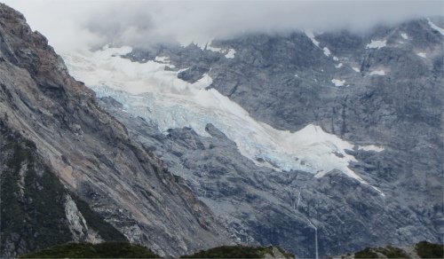
Anxious to clear off as much as I could in one day before the rains came, I then made my way back to the campsite, and began the hike up to Hooker Lake by Hooker Glacier. Traversing scrub and scree (the greywacke rock being easily shattered in the cold, leaving huge amounts of gravel), I soon found myself looking out over Mueller Glacier Lake, Mount Sefton and the Footstool. Here were the Mueller, Huddleston and Stocking Glaciers. Occasionally I would hear gunshot like sounds. These were due to the ice fields far above me cracking. Once I had taken my fill off this wondrous sight, I proceeded a while before winding my way down to the Hooker River. My way across was via a rope bridge, known in Kiwi speak as a swingbridge because it can't half swing. I relished the crossing. I stopped halfway across to gaze at the thundering, milky-blue waters rushing below me carrying their powdery blue rock flour, ground down by the Hooker Glacier, to be deposited far down stream.
Hooker Glacier Covered in Surface Moraine
|
The Wakefield Track joined at the far end of the swingbridge, and I turned to a northerly heading to skirt the eastern bank of Mueller Glacier terminal lake. Around me, the alpine foothill setting was enhanced by a splendid array of plants.
The track roller-coasted alongside the lake, the pure mountain air whistling across the placid lake seared my lungs. A section of the path was actually cut out of the rock face, which didn't deter me; I had encountered such hazards in Zion Canyon, Utah, before. Eventually I reached a second swingbridge crossing the river. The route tracked the river, with cloudy views of Aoraki Mount Cook unfolding as I climbed the narrowing trail. I was surprised to find toilets at the junction with Stocking Stream, and the accompanying shelter must have probably provided welcome relief to hikers who had been caught unawares by rapidly changing weather.
Towering far above me, and shrouded in mist, was Aoraki Mount Cook, an overwhelming and spellbinding presence in the valley, forming the centrepiece of a giant canvas of snow-capped mountains, glaciers, rivers and lakes. Mt Cook was named in 1841 after the great navigator, by Captain Stokes of the survey ship
HMS Acheron. It was interesting to note that Cook did not actually see the peak when he sailed past in 1770. According to Ngai Tahu legend, Aoraki and his three brothers were the sons of Rakinui, the Sky Father. While on a sea voyage, their canoe overturned on a reef. When the brothers climbed on top of their canoe, the freezing south wind turned them to stone. The canoe became the South Island (Te Waka o Aoraki); Aoraki and his brothers became the peaks of the Southern Alps. The mountain was unconquered until 1894, when three young Kiwis: George Graham, Jack Clarke and Tom Fyfe, made it to the top on Christmas Day.
I headed up the track towards the grand peak, and after a while came upon Hooker Lake. Like Lake Tasman, it too was milky in colour. I walked along the shore until an icy cold river off one of the glaciers impeded progress. There I sat down, tucked into the supplies I had brought with me, and just absorbed all the scenery around me. Similar to Tasman Glacier, Hooker Glacier was also covered in surface moraine.
I took in my fill of this glacier until I noticed the temperature had noticeably dropped, and then started the long hike back to camp. It was a varied hike which kept my interest, so I enjoyed it as much as the hike out. All in all, it had been an excellent day amongst the glaciers close to the invisible Mount Cook.