You Have Been Warned
|
I passed the Aukopae Tunnel and the remains of Aorangi Flour Mill before taking another detour to Maraekowhai Reserve, a site of considerable historic significance. It was a stronghold for rebellious Hauhau Warriors, part of an initially peaceful religious movement in Taranaki, which became disenchanted with the style of European land acquisition. A war pole "rongo niu" was built in 1864, with four arms, which it was believed radiated out in all directions, calling warriors to the cause. They danced around the pole to incantations, in the belief that it would make them invincible to musket fire. A peace pole "rere kore" was built at the end of hostilities and both poles were now supposed to be preserved on the site.
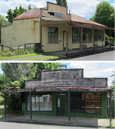
Downtown Ohura
|
It was a 17km drive down a gravel road to the Reserve, trailing a white cloud of dust behind me. Light entertainment was provided by four sheep, who insisted on galloping down the road in front of me. I followed these stupid animals for a while, and then stopped, hoping they would move to one side. They just stood there looking at me. I slowly edged forward, and the most intelligent, the one with two brain cells, moved slightly to one side. That was the trigger for the others to follow, and at last I was past this wee traffic holdup.
The journey seemed to take ages, but at last I reached a dilapidated sign that said "Car Park". It was a muddy patch of ground, with a rusty JCB in the corner covered in tarpaulin. A huge water-filled hole lay beside the machine, I guess for a septic tank for some toilets due some decade from now. I looked around for a pointer to the historic reserve, there was nothing. I spotted a trail and followed it. Further tracks branched off it. Which one do I take? I took what seemed to be the main trail, and followed it for 20 minutes. I heard the Ohura Falls thundering way below me, but I was so high up in the bush that I couldn't see them. I knew from the signs 18km away that the falls were beyond the reserve, and I turned around and headed back, considered taking a different path, but thought better of it. I walked all around the car park area looking for clues, but it was hopeless. This was meant to be a heritage site, and the directions to it are non-existent. What was the point of advertising it in brochures if people can't find the place. There is a serious disconnect between the DOC or whoever is responsible for such sites, and the firms that print glossy brochures.
I drove the long route back to the highway, silently cursing. My next port of call was Nevin's Lookout. The brochure showed where this was located. I appeared to have missed it, and I retraced my steps, but gave up. Then, some kilometres further on I came across the sign. The brochure had totally got the location wrong. I was losing faith in it by now. I climbed up to Nevin's Lookout, and was afforded superb views of the King Country and the Central North Island mountains. The view more than made up for the hassle I had in finding it.
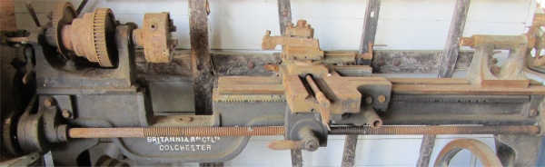
1860 Colchester Lathe
|
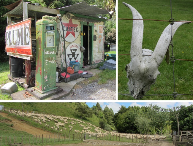
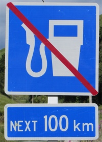
I took another 10km detour to Ohura township, passing a sign on the way indicating that there was no fuel for 100km. I have even seen signs quoting 150km; quite common down under. I arrived into what appeared to be a ghost town. I parked up and walked down the middle of the street. Long finished businesses were now just dilapidated shells on the main street. There was not a soul to be seen; I felt I was in a Clint Eastwood western movie. I found the museum shut with an "Open by Appointment" sign. A note said check at the store. The store was only 20m away, but it had long been closed. I wandered around looking for signs of life, the only life seeming to be the noisy frogs in a pond, they sounded like chainsaws. Mating season is around the corner. Then I caught a movement in the corner of my eye. I homed in on an old dear who was tending to her roses. "Excuse me, does the museum ever open nowadays?" I asked. She looked around, wondering where the voice had come from, and then spotted me. With a big smile she said, "I'll give someone a call. Come and talk to my husband while you're waiting." I entered her garden, and around the corner sat hubby on a bench, nursing a pair of crutches. "What happened to everybody?" was my opening remark. He sighed, with distant memories in his eyes, "When the timber and coal ran out, the place went downhill. Nobody wants to start a business here now, we are 50km from anywhere. The supply lines for industry have long gone."
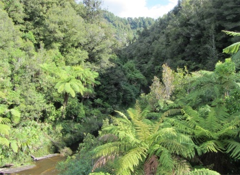
Tangarakau Gorge
|
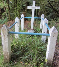
Joshua Morgan's Grave
|
He told me how the store had closed over three years ago, but he and his wife are now content to see out the rest of their days is this forgotten place full of memories. The couple had visited Wales for eight days back in the early 80s, when they could buy a cheap 1st Class runabout train ticket. He was particularly pleased that they had 1st Class tickets since the carriages were more often than enough empty, apart from the commuter periods.
Presently, Angela turned up, a lady probably in her 70s. She would open the museum up for me. I thanked the old couple, and followed Angela the short distance to the museum. She was a chatty lady, a very chatty lady, she just couldn't stop talking, but I didn't mind that. Within a very short space of time I learned that she had inherited the curatorship of the museum, and she alone is trying to sort out all the numerous artefacts, photos, repairs and just about everything. It didn't seem to get her down, she enjoyed meeting the folk who visited. I think she enjoyed having all these folk to talk to. She was indeed a happy soul, and once I had spotted some mining artefacts that I took an interest in, I was inundated with box files of exercise books containing minutes of meetings from the turn of the century, photos, press cuttings etc. One large mining exhibit had a huge Union Jack draped at the top of it. I queried this. "Oh, when all the New Zealand coal miners went on strike, they started bringing out Union Jacks." I never did get to grips with that one. Every household item conceivable was stored away on musty shelves in the museum. Also included was a road menders dwelling.
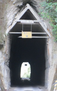
Moki Tunnel
|
Outside, in the large covered shed, she showed me more mining memorabilia, farming equipment, pianos, but the real show stopper was a Colchester lathe. "Oh, that used to be in the local garage," she said, "It was brought over from England in 1860." I told her my brother-in-law's father used to work for Colchester lathes.
As I looked around, Angela kept on chatting, and she chatted with the two young local lads who had turned up, but she kept a constant eye on them. I showed her my route along SH43, and the brochure. She scanned it, but when she spotted the brochure's comments on Tatu, she stated they were totally incorrect. That really got her dander up.
The whole museum reeked of times gone by, haunted by the ghosts of those who had once possessed its contents. The outside shed had layers of dust on the tools on the benches, a dusty dirt floor and a liberal scattering of cobwebs, but it all lent to the air of an antiquated museum and possessed real character. I felt privileged to have been show around. I thanked Angela, she had been a kind, helpful and happy soul with a mischievous sense of humour. We shook hands and parted. I could still hear her talking as I drove down the road.
I drove further along the highway, and pulled in just after a bridge. A short trail brought me to the last resting place of Joshua Morgan, a pioneer surveyor who blazed the trail for the road through the Tangarakau Gorge. While in charge of the survey party in this remote area in February 1893, Morgan became severely ill with suspected peritonitis. His assistants J. Laing and W. Teller hurried out to the coast at Urenui to bring back medicine, which relieved the pain temporarily. Then A. Thompson went out a week later for further medical supplies as Morgan was now delirious. However, before Thompson had returned, F. Willson, Morgan's chainman, had come out through the rugged bush with the sad news of Morgan's death. His grave is considered a memorial to the men who had to find a way through this difficult country.
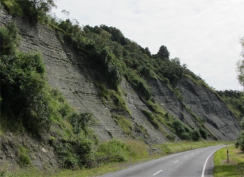
The highway snaked through sedimentary sandstones and limestone with steep 200m native bush-draped cliffs rising up from the river, into Tangarakau Gorge. Large coal deposits originally formed in ancient peat swamps in a low lying prehistoric landscape, and were mined in several locations in the Gorge. Small pockets of coal could still be found adjacent to the Gorge site sign. A rapid-whitened, rock-strewn, snag-cumbered river, tearing along between lofty ranges, wound its way at the bottom of this grand ravine, with the timber debris of a thousand floods strewn along the bottom of the gorge. The river's roar echoed up from the depths below. The road surface was just gravel for quite a distance, and I came across where the slips had been that the old man had told me about at the campsite. Indeed, all along the Forgotten World Highway, there was evidence of numerous slips, with chunks of rock on the road quite common.
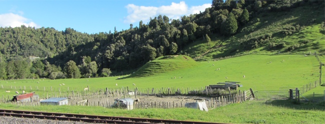
Where Tangarakau Village Once Stood
|
Back on the highway, at the crest of a ridge, I drove through the dark, narrow 180m Moki Tunnel built in 1936. The tunnel was the only one constructed of five that were originally proposed for the route to Stratford by Joshua Morgan in the early 1890s. The floor was lowered in 1985 to allow triple-decked stock trucks to pass through.
A short distance further on, a turn off took me to Tangarakau, the name derived from the "felled trees" cut down by the legendary Tamatea to repair his canoes on the Whanganui River. First settled in the 1900's the village boomed in 1925 when it became home to 1200 people, the families of workers on the nearby railway. I drove the 6km gravel track, and again at the bottom I was confronted with an option as to what routes to take, with no clear indication where the site of the village was to be found. By chance I took the correct turning.
Tahora Saddle provided another spectacular vantage point for the central North Island mountains and surrounding valleys. From the saddle Maori pa sites were visible on hilltops to the west and east. As I gazed out, I got chatting to a farmer who was sat in his car. He had just been talking away on his mobile. He had a ruddy complexion, a bit like Santa, and wore a powder blue deerstalker, to keep the sun off I guess. "I live on the farm down there in the valley," he said, but cellphone reception down there is zilch. That's why I come up here to make my calls." As he left he shouted out, "Enjoy your Christmas and have a good trip!"
I arrived at Whangamomona campsite. The owner wasn't one for formalities, he just smiled and said, "There's the toilets, showers are at the back." I walked up to the Whangamomona Hotel, ordered a salad and a beer, and watched a crowd of motorbike guys play a pool knockout match. They were good blokes just having fun, and the room was filled with mirth.
I strolled back to the campsite in the dark. This place was many miles from civilisation. A consequence of that was there was no light pollution. I looked up at the night sky, and was awestruck with the clarity of the stars and the vast band of the Milky Way painted across the heavens. I could recognise Orion's Belt, but that was all in this southern hemisphere. It was a marvellous sight though.