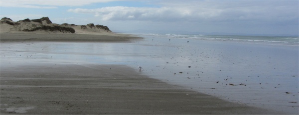
Ninety Mile Beach -It Just Goes On and On
|
I began the day by skirting the southern shore of the greater Doubtless Bay (as opposed to the small inlet that Hihi sat on). This was an expansive bay laced with over 70kms of unspoilt delightful beaches, ranging from Pohutukawa-fringed, tranquil white sands to rugged rocky coves. When Cook sailed past in 1769, he noted in his log that it was "doubtless, a bay". He was correct, and the name stuck, Doubtless Bay. Kupe, the first Polynesian to discovered these islands, is said to have first set foot in Aotearoa in Taipa, half way along the southern shore of the bay
As I headed around Rangaunu Harbour, the road veered northwest along the Aupori Peninsula, a narrow 100km finger of land anchored at its northern extremity by a clump of 60-million-year-old volcanoes at Cape Reinga. At one time the whole peninsula was carpeted with kauri trees, but now vast dune systems and swamps dominated the landscape, threaded by a ribbon of commercialised pine forestry, the Aupori Forest, a Narnia-like place where bands of wild horses roam free amid legends of a shipwreck lost in the mists of time. To the east, blinding white dunes were caressed by Rangaunu Bay and Great Exhibition Bay, today being pounded by the Pacific Ocean. Strong winds were coming in from the east. To the west lay Ninety Mile Beach, though ninety kilometres would be nearer the mark. This was a long, straight, continuous stretch of sand by the Tasman Sea, today relatively tranquil due to being in the lee of the land. This shore line was cursed with lethal rip tides, and bounded by ridges of high dunes. The main road ran down the centre of the peninsula, with the strip of forest obstructing the view to the west. Ninety Mile Beach was officially part of the state highway system, and specifically designed tour buses zipped along it on their way to the cape; tides permitting. However, soft areas and quick sands render the beach route inadvisable to newcomers, indeed the insurance for private and rented vehicles was not valid for this stretch of "road". Rescue services and phone coverage for the area was almost non-existent, leading to bogged down vehicles often being abandoned to the sea.
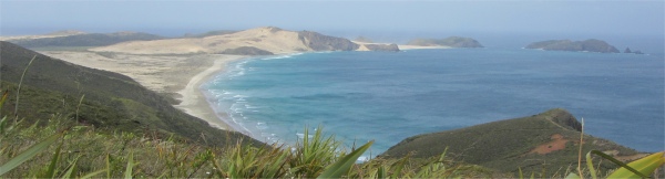
Cape Maria van Diemen - the Most North-westerly Point of the Nation
|
Having said that, I took a turn off at Pukenui, and started heading down a road to Hukatere, which the map indicated was by the Ninety Mile Beach. I was contentedly driving at 100km/hr along a long, straight, undulating road, enjoying the roller-coaster experience, when suddenly the road disappeared, and a moment later I landed on a rutted gravel forestry commission road. There was no sign to give warning of this. My front wheels hit a rut when I landed, and started to turn, but I managed to slither back into a straight line. It was a temporary shock, but I soon got over it. The next 10km were along this rutted track. All of a sudden I rounded a bend and there was the beach. Hukatere looked as though it consisted of one building devoted to fishermen or surfers; I paid it no attention. I broke the rules and gingerly drove along a compressed sand track between dunes onto the beach, heartened by the fact that there was already a car parked on the beach. A bloke was steadying his expensive looking camera on top of the car, taking pictures of the crashing waves.
The Colliding Tasman Sea and Pacific Ocean
|
I parked a discrete distance away, and ambled in his direction with my humble compact camera at the ready. "How's it going, mate?" was my opener; fairly standard for these parts. The chap had been up to the cape, and was making a very long trip back to his home town of Hamilton. I wished him luck on that one. We talked about my trek, and he was surprised at the deal I got on the hire car, "Might as well hire for that price," he said. "Where in the UK are you from?" he asked. "Ipswich, East Anglia, about 70 miles......" "I know it," he interjected. He had once lived at Ely; not far away from my adopted home town. He had recently been back to Scotland for a spot of climbing, but slipped 20m and managed to break his leg. He tapped the plaster cast as a trophy. Not bad for a guy of 69 years. We talked about the beach and the convoys of busses that hurtle along when the tide is right. Then he cursed, "Strewth, the water's almost here. Once it gets to your wheels you are well and truly in trouble. I'm out of here." He leapt in his car and was gone. The water had indeed covered a lot of ground in a very short space of time. I wasted no time, and followed his example and quickly retired to safer ground.
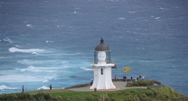
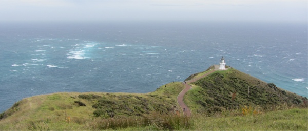
Cape Reinga Lighthouse
|
I returned back to the main highway and continued the long haul up to the tip of the peninsula, passing huge herds of cattle and paddocks full of horses. That was all there was up here apart from the forests. I could sense I was getting close to the cape since I started to get glimpses of the sea to my left and the ocean to the right of me. And then I was there, parked up in a very bleak looking car park with a dozen more cars and vans for company.
Cape Reinga is based on a clump of 60-million-year-old volcanoes. Twelve degrees below the Tropic of Capricorn, Cape Reinga thrusts its gritty head north to bask in subtropical sunlight. Almost one quarter of the land at this north extremity is owned by local Maori. The area is steeped in Maori tradition and regarded as sacred. After death, all Maori spirits wander up the desolate Ninety Mile Beach to the 800-year-old pohutukawa tree on the headland of Cape Reinga (Te Rerenga Wairua: "escaping place of the spirits"). Here, the souls slide down a root to fall into the sea below, and make their way through the underworld where they climb out again on Ohaua, the highest of the Three King Islands 57km offshore. It is there that the spirits bide a while, for one last look back towards the land before they bid their last farewell and return to the land of their ancestors in Hawaiiki.
I Just Couldn't Leave Without Getting a Photo
|
Te Rerenga Wairua marks the separation of the Tasman Sea from the Pacific Ocean. For Maori, these turbulent waters are where the male sea, Te Moana Tapokopoko a Tawhaki, meets the female sea, Te Tal o Whitireia. The whirlpools where the currents clash are like those that dance in the wake of a waka (canoe). They represent the coming together of male and female, and the creation of life.
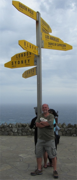
For us mortals, our transported journey ends at this windswept car park with a few blockhouses containing a toilet and small shop, and a letterbox. A trail led to a short gleaming lighthouse, and a signpost pointing to Vancouver, Los Angeles, Sydney, and London etc. A few metres of spongy turf brought me to a dramatic 165m cliff dropping down to Columbia Bank. This was truly the edge of the "world". Below me the Tasman Sea and Pacific Ocean clashed, the different water currents and wave structures colliding into a maelstrom of boiling 10m high waves and surf. The awesome sound of two mighty oceans merging was mesmerising. 2000km to the west lay Australia, and much, much further to the east sat Chile. To the north, past a few islands, lay artic Russia. With this vast expanse of ocean spread before me, it was easy to understand how 70% of the earth's surface is covered by water. Standing there alone, it was a sobering and awe-inspiring experience, trying to comprehend the scale of it all. I have sailed around UK waters, and even across the North Sea and around the Baltic, but the watery wilderness before me was orders of magnitude beyond what I had experienced.
However the Polynesians, that remarkable breed of fearless, seafaring navigators, were not intimidated by the immensity of the ocean as they explored the Pacific in their primitive outrigger canoes. They had brought back the kumara or sweet potato from South America, and in turn brought it with them to Aotearoa.
The cape is often mistakenly thought of as being the northernmost point of the North Island, and thus, of mainland New Zealand. However, North Cape's Surville Cliffs, 30 km east of Cape Reinga, are slightly further north. Another headland just to the west of Cape Reinga is Cape Maria van Diemen, the most north-westerly part of the nation, which was discovered by the Dutch explorer Abel Tasman during his journey in 1642, and named after the governor's wife in the Dutch East Indies, where his expedition had begun.
There was a howling gale coming in from the east, and the poor guy I had asked to take a photo of me was struggling to keep steady in the winds that buffeted him. I wanted to spend more time here, just to savour the moment and marshal my thoughts about the Maori reverence for this sacred place, but the screaming wind won, I'm afraid.
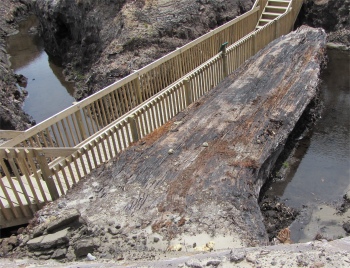
I now began the long, long journey to the south of the country, retracing my route back down the peninsula, trying to imagine what it must have looked like when it spent 100,000 years cloaked in kauri forest. Like my native English Lake District, it too had been stripped bare by settlers a long time ago. During those millennia, kauri trees had oozed sap or gum which had collected around the bases of the trees, and the trees had later toppled when their rotting interiors could no longer support their colossal weight, or sheared off and flattened onto the ground by a cataclysmic event 45,00 years ago. The hardened gum, resembling translucent amber nuggets, was prized by European settlers for its use in making varnish and polish, and soon gum harvesting turned into big business. Kauri gum is quite often mistaken for amber. However, it is younger than true amber, and is less durable. The correct term is Kauri Copal, Copal being derived from the Spanish word "copalli" meaning incense.
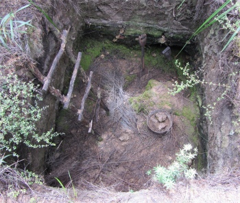
Gumdigger's Hole
|
The gum originally littered the ground, clustered around old trees stumps, and had been collected by the Maori for uses such as chewing, tattooing and lighting fires. However, the Europeans soon hoovered up the surface gum, and diggers, mostly Dalmatians (Dallies), probed the ground and hooked out chunks. Eventually gum was extracted by digging and even sluicing techniques. By all accounts it must have been a hard, grim existence. Gumdigging became a major industry in the area from the 1870s to the 1920s, resulting in desolate areas resembling the remains of shell pocked First World War battlefields I had observed near Ypres in Belgium. Near Waiharara, a gumdigging site had been turned into the Gumdiggers Park, which I decided to make a detour to.
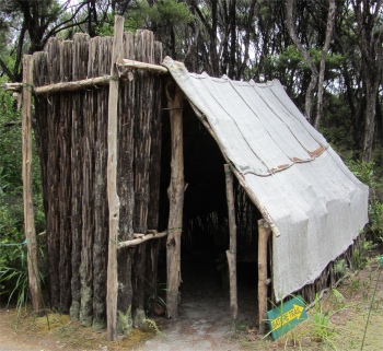
Gumdigger's Dump or Shelter
|
I was greeted by a guy in his early fifties, who gave me a little spiel before I entered the park. He mentioned how kauri forests had existed here 100,000 years ago, and the huge trees would have fallen naturally, due to old age or disease, into the swamps that surrounded them. The acidic waters preserved the timber well. Global warming raised the sea level, allowing the swamp to be buried in a layer of sand, which hardened through chemical reactions into a soft form of sandstone. Global cooling dropped sea levels, and the kauri grew again. The process was repeated a few times, but around 45,000 years ago some cataclysmic event toppled all the trees in one particular direction. Various theories abound as to what the event might have been: a tsunami, hurricane, meteorite strike. The case is still open. I went off to explore.
100,000 Year Old Excavated Kauri
|
A tangle of paths lead through reproduction huts, ancient kauri stumps and diggers' holes. A video room along the way gave a comprehensive story of the kauri forests, and their exploitation by the Maori and then the Europeans. An expanse of land lay beyond the fenced off area, full of gum holes, and many full of water which never dried out. The undergrowth covering it was so dense and impenetrable, obscuring the deep holes, that the area was regarded as totally off limits. The stumps of a few old kauris were on display, their tops being a metre or so below ground level. My, these were massive trees. One tree had only just been discovered in the park four months ago. It was at a deep level; in fact a slice through the earth showed earlier swamp material sandwiched between sandstone layers, including the cataclysmic 45,000 year old level. This massive old tree was 100,000 years old, and was still as hard as concrete.
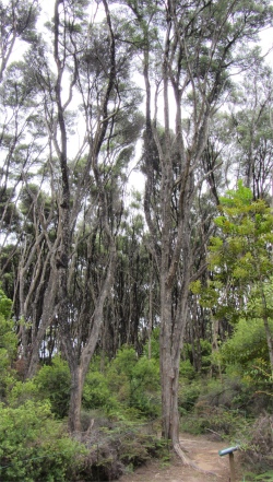
Tea-Trees
|
I meandered around a nature trail that was included and came across groves of tea-trees, so named by Cook as his sailors used the leaves to make a kind of tea. I also came across the Ponga tree fern. This tree fern is native only to New Zealand, and is one of the nation's national brand symbols, being found on anything from pure New Zealand butter to the All Black's jerseys. The Ponga can grow up to 10m in height with individual fronds growing up to 4m in length. The underside of the fronds take on a silvery-appearance when the plant reaches four years of age. The silver fronds were used silver side up by Maori along trails at night so that they could make their way.
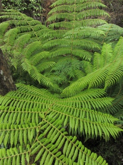
Ponga Tree Fern
|
Once I had seen enough, I returned back to the office where I had met the guy earlier, and we had a chinwag for about an hour or so. I asked him about how they intended to preserve the massive kauri they had just unearthed. In four months if had already started to deteriorate, but the park is privately owned and runs on a low budget, so there is little funding to cover such efforts as preservation. He showed me the shovels that the gumdiggers used. These had been manufactured in Sheffield, unique in that they had very long stems for the wooden handle to slot into, and were called Skeltons. Curiously, part of the stampings on them included a swastika, which meant "conducive to well-being" in ancient times. Of course events in the Second World War stopped that practice. I told him about a similar type of venture that occurred in Norfolk, UK, way back in Neolithic times. Then, at Grimes Graves, men dug bell shafts in the chalk and excavated flints. The chap had actually come across that before.
We chatted about more personal topics. He would love to travel, and he acknowledged that there are still parts of New Zealand he would love to explore, if he had the time and money. His grandfather had worked in a coal mine near Sunderland, and came out to New Zealand to take up the same occupation there. We had something in common on that score. Apart from relatives in Auckland, he had a sister who lived at Leigh-on-Sea, and he was hoping to visit her next summer. "Just in time for the Olympics," I said. "Ah, that may not be a good idea," he stated, "it might be expensive and busy." I encouraged him to make the journey, He would regret it if he continually puts it off. He laughed, and we continued to put the world to rights, before I shook hands and took my leave.
I then undertook another long drive south. I was heading for the western side of Northland to visit a couple of forests. My long trip was given a little variety by the ferry crossing over the Waihou River. I pulled in at Opononi for provisions and petrol. This area is remote, and I would not have the opportunity again until I reached Dargaville. It was getting late, and I had done a lot of tedious driving today, so I found a campsite in the village to settle down for the night. Indeed it was the only one this side of Dargaville, the rest were closed.
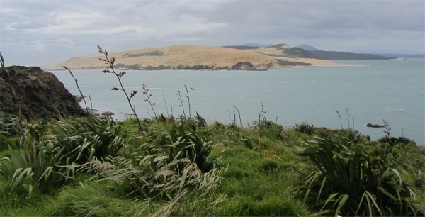
Massive Sand Dunes Opposite Arai Te Uru
|
I drove up to Arai Te Uru lookout and took the opportunity to snap a few pictures of the colossal sand dunes just across the mouth of Hokianga Harbour. As I left my car, the only one in the car park, a local chap marching by approached me and said, "Are you walking along to the far point of the walk? It's 20 minutes walk you know." "No," I replied, pointing to a small hillock, "I'll just walk across to that high point over there." "Good," he replied, "there have been a few car break-ins recently. Right arseholes they are, just completely empty the parked cars. The security has now finished for the day, so these thieves start their day." I thanked him as he continued his march. I was hoping to see folk sand tobogganing down the dunes, but high winds whipping up the sand would have put a stop to that.
I retired back to the campsite, and set up house in the communal kitchen area to type up the blog you are now reading. A young Swiss couple came in to cook a meal. They had just spent a month driving around Australia, and were now spending three months cycling around New Zealand. Now that is what I call super fit. We joked together about the Maori language, they were having difficulty getting around the pronunciation, which I can understand. I am starting to get the hang of it from my tune-ins to the local radio stations. They cooked their supper, and parted, all wishing each other bon voyage.
All in all, it had been an interesting day. Tomorrow might be a different story if I believe the weather reports.